Below is the
complete set of daily emails from our cross country trip. The yet
to be completed google maps version can
be found here:
Driveabout
First day of
trip
Hi
all,
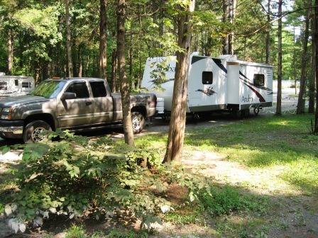
Well, in true Josh & Denise style, we left Hollis yesterday at
around 5:00 p.m. to START our trip – having no idea where we are
heading, except that we wanted to go west. So, we got in the truck
with the camper in tow and headed to our local sub shop (we’d been
so busy packing and organizing that we hadn’t eaten lunch). With
our subs in our laps, we headed west on Route 130 toward the Mass
Pike.
Finally, at the rest stop on the Pike just outside of Springfield
(about 7:15 p.m.) we began thinking about where to stay. I had sort
of thought we’d try for Lake George area, but it was too far north;
then I thought maybe we’d make it to around Cooperstown, but that
was too far southwest; so, looking through the Woodall’s Camping
Guide, and being a new and proud KOA member, we located a KOA
campground in Saugerties/Woodstock, NY, which is just on the eastern
edge of the Catskills. After reaching it campground’s answering
machine several times (the office closes at 8:00 p.m.; it is now
7:45 p.m.) and unsuccessfully trying to book online (can’t make an
online reservation after 4:00 p.m. on the day of arrival), I finally
reach a nice woman who is very helpful and reserves a site for late
arrival.
We
reach our site at about 10:00 p.m. and begin “hooking up” the camper
for the first time. Having never used the “loo”
in our new camper, we had to call Mike on the cell phone and get his
expert advice on the intricacies of camp toilets.
Dinner our first night in our camper was take out Boston Market
which we foresightfully purchased while
at the rest area on the Pike and which we stored in our brand new
refrigerator (which we were using for the first time) and cooked in
our new microwave (which we used for the first time). Oh roughing
it, how sweet….
Then
taking out our maps and connecting to the campground’s free
WiFi, we proceeded to try to chart
Thursday’s course. With a tentative course planned, we were off to
sleep for the first time on our new camp mattress (which wasn’t so
new because Jeff & Erica got to sleep in the camper in May, lucky
them!). It was so quiet in the campground that we both had trouble
falling asleep. But, we finally did; and we slept through until
bright and early this morning (9:30 a.m. – we were pretty much the
only ones left in the campground at that hour).
As
you can see from the date stamp on this email, we’re not exactly
rushing off to find new and exciting things – we’re just leisurely
sitting here at the kitchen table, eating our corn muffins from last
night’s Boston Market meal, and again using the campground’s free
WiFi to write to you all.
We’ll probably head out in the next half hour. Don’t know where
we’re going, but we’re going in style.
Talk
to you all later.
Dee
and Josh (we don’t have nicknames yet – any suggestions?)
Day 2 - Watkins Glenn
All,
Spent the night in Watkin’s Glenn last
night.
Not as nice as the last place. We are on a bit of a hill so that
has made life a little interesting. I’ll pick up some boards at a
Home Depot today to raise one side if we have this issue again. We
also had to unhook the truck, both to get level front to back and
because the pull through site was too short for truck and camper
(and our camper isn’t that long…). It is fun to learn these things
along the way. We also learned that “scenic view of a small valley
with a steam and train tracks” means that at 10:30 PM a freight
train basically pulls through the campground blowing
it’s whistle the whole way. I’m really
glad we were several sections away from there, but the people who
took the “scenic” must have had fun.
Also
learned a lot about the new truck and the expensive transmission
yesterday.
We chose a nice route of back roads, and there was a lot of great
scenery. However, AAA maps are not topographical, so we didn’t
realize that we were driving right through the Appalachian
mountains. There were several hills that
we went up at either 35 MHP or 3500 RPM, and since the transmission
uses the engine to slow on the down hills we hit over 4000
RPMs a few times. I’ve never seen an
automatic transmission vehicle do that before, it is an impressive
sound. Also, the roads all had small towns with stop sign’s in each
valley so we had to stop at the bottom of big hills and then start
up the next hill from a dead stop.
Today we are headed towards somewhere between the PA shore of Lake
Erie and Canton, Ohio. We want to see the lake, and will try to
stop at the football hall of fame -- we have been to the Baseball
hall in Cooperstown and the Hockey hall in Toronto on previous
trips. (Interestingly, the closest pro sports hall of fame to us is
Basketball in Springfield, Mass. But neither of us
are interested so we’ve never been).
Also, I had trouble with Denise’s email account at the last
campground, and this place requires you to go to the office to get
an ID to use the free WiFi, so I am
typing this email but probably won’t actually send this one or
yesterday’s until tomorrow.
By
tonight or tomorrow, we should be out of the states that we are used
to and into the uncharted regions of Ohio (which of course has been
considered charted and civilized even before Lewis and Clark).
-Josh and Dee
Friday, Day #3
Hi
all,
So,
today we left Watkins Glen and headed west along route 417 which was
a nice 2-lane blacktop with rolling farms of corn and cows. Then we
headed south on Route 62 down into PA
which brought us through the Alleghaney
National Forest which followed the Alleghaney
River. It was very narrow and a little scary.
Along the southern border of New York we drove through some very
small towns and a lot of economically challenged (forgotten)
places. We found a nice Veterans Park in Olean, NY and stopped to
have lunch. The weather was high 80’s and very muggy, but there was
a rather stiff breeze in the park so it
felt much cooler.
The
truck seemed to struggle less today – Josh is still experimenting
with Tow/Haul mode and whether to keep it on or not! To me it seems
to work better with Tow/Haul off, but I’m not driving.
We
ended up finding a KOA campground in Mercer, PA.
This is nice also, we may stay through
Saturday! Again we arrived too late to go in the pool – it closes
at 8:00 p.m. So we decided to unhitch the truck and find beer and a
restaurant. Beer is not easy to find in PA. They don’t sell it at
gas stations; they don’t sell it at grocery stores; they don’t sell
it at “Wine & Spirits” stores (which are next door to the grocery
stores). No, you have to drive out into the boonies to this really
seedy, dark, poster plastered windowed place that looks like a
dive. I refused to go in, so Josh did the honors. The following is
his rendition of the experience…
So I
walk in, there is a counter, a display of dusty beer cases and a
roped off room that looks like the guy might live in it. I ask if
he has Miller Lite. Yes. I ask if he
has it cold. Yes. OK, I’d like a cold six pack. “I don’t sell six
packs, I’m a beer distributor! If you want a six pack go to a
bar!” OK I’ll take a cold case. Now I need to show ID, proof of
citizenship, pass a criminal background check, DNA test,…
So he goes back into this storage room, the door is hanging by one
hinge, and comes back with a case. He won’t hand it to me, but puts
it on what appears to be a beer transfer platform. From there I am
allowed to pick it up and go. On the way out I pass two old ladies
in a beat up Ford four door, pulling in
to get their beer from the “distributor”. I’m assuming I could
probably buy drugs here in Mercer PA more easily.
Having secured beer (an essential vacation ingredient), we proceed
to find a restaurant. They don’t seem to have “chain” restaurants
(other than fast food joints) here on Mercer’s strip and life style
mall. We have a choice of: a Mexican restaurant in a three story
Victorian (is it me or do these two concepts just not go
together?!); Hoss’s Steakhouse Buffet;
King’s Family Restaurant, or a place called Elephant and Castle.
The first three we self-explanatory and didn’t appeal to us, so we
decided to try the Elephant and Castle. You’d think it might be an
Indian Restaurant, but it appeared that it wanted to be a British
Pub. So the menu had such items as Shephard’s
Pie, British Fish & Chips, etc. There were a lot of people there,
so we figured – “How bad can it be?” As it turns out, it wasn’t bad
at all.
So,
after getting back to the campground and with the TV now hooked up
to campground cable, we were able to catch the news which predicts
cloudy and ? rain for Saturday. So,
we’ll see what tomorrow brings.
That’s it for now.
Dee
& Josh
Saturday,
Day #4
All,
Decided this morning to stay an extra day here in Mercer, PA to get
some stuff we needed and to take it easy a bit. Once again we got a
late start, but we did get a few things done this morning – built a
leveling system from some wood we picked up at Home Depot yesterday,
dumped the waste water tanks for the first time (thank you Camper’s
Inn for leaving the black water tank valve open…). Since the truck
was already unhitched from the camper, we went for a drive around
western PA and saw a lot of farm country on really small roads that
would not have been trailer friendly. On the way back we stopped at
the local market to buy dinner for this evening (BBQ chicken) and at
(ugh) Wal-Mart for a dish rack, a larger cooler (since we are now
the proud owners of a full case of Miller Light), and a bunch of
stick on hooks since it turns out there are a lot of things that you
want to hang up in a camper.
In
general, it seems that things are not going well in Butler, PA.
Last night on the news there was a story about a guy in Butler who
was tasered by the police when he forgot
to turn off his home alarm system. This afternoon while we were out
driving about we wound up in Butler, looking for a gas station, and
heard the clerk and a customer talking about a local beer
distributor (now we know what that means) who was shot last night.
Speaking of looking for gas stations, one of the things that
is starting to become an issue in western
NY and PA is the lack of gas stations. Yesterday afternoon in an
hour of driving, I counted seven car dealerships and five auto parts
stores and only two gas stations (which seems backwards to me). We
passed several gas stations that had gone out of business, but it is
remarkable that there are so few. This is both an interesting
observation about the economy and a potential concern since we are
driving a rig that is averaging about 8.5 miles per gallon and only
has a 26 gallon tank. I thought about getting a second tank
installed in the truck before we left but decided against spending
the money. I expected to have to pay more attention to gas out
west, but we are still not too far from home. It is not like we are
going through wilderness, it is constant towns and yet there are
simply no gas stations for miles and miles. People in a lot of the
towns we are passing through must use a quarter of a tank of gas
just going to the gas station and back.
After we got back to the camp ground, even though there were
scattered thunderstorms, we actually used the pool here. We are
actually taking advantage of a lot of the campground features here
that we haven’t at our previous stops. We even talked about using
the bathhouse showers, but in the end we decided to use the shower
in the camper, which means I’ll have to dump that tank again in the
morning (someone takes long showers). On the bright side, the hot
water seems to last for an entire shower – even a long one.
Dinner came out good, and we used the stove for the first time. I
think this leaves the oven as the only system we have not yet used
or at least tested, and we are going to wait on that until the
weather cools off. We have used the air conditioner a lot in the
last few days. Two other things we have discovered are that the
circuit breaker blows if you use the microwave, the oven vent fan,
the air conditioner, and the outside lights all at the same time,
and that there is a small leak in the shower door.
Always something to retrofit.
-Josh and Dee
Sunday, Day
#5
Hi
All,
Sunday.
Oh what a day! We woke (at 8:30 a.m. – we’re getting on a little
bit earlier schedule) to rain – meaning we had to breakdown in the
rain this morning. We also found out that, even though we “dumped”
yesterday a.m., when we both take showers and cook and clean up
after a full meal, we fill the grey water to 2/3 full; so, Josh got
to test out his newfound “dumping” skills again this morning. After
the “surprise” of his first try, this one went much smoother.
I
don’t know what it takes normal people to get up, get going, and get
out; however, I’ve figured based on the last few days that it takes
us about 2 to 2 ½ hours from wake up to drive. This seems to be the
case regardless of whether we shower at night or in the morning. I
don’t know if this is good or not good; but it seems to coincide
with how long it takes us to get going whether we are at home, in a
hotel room, or at the lake house. I guess we are just 2-hour prep
people – wherever that puts us in the general population. Do you
think anyone does statistics on this kind of stuff?
So,
driving out of Mercer, PA, we headed north then west to Canton,
OH. One might wonder why we would intentionally go to Canton, OH;
however, for those of you out there who follow sports, you’ll know –
the Football Hall of Fame. We got there at about 1:00 P.M. Thank
goodness the parking lot was empty because there were really no
spaces for trailers even though the sign indicated that one such
place did exist – we didn’t find it. We ended up parking sideways
at the far end of the lot and took up about 10 spaces. Rather than
make lunch in the camper, we decided to try the fare at the Hall’s
Tail Gate Snack Bar. The lady behind the counter was definitely not
happy that people were arriving at her counter to order “tail gate”
food, some of which they had already run out of at 1:00 p.m.!, but
we managed to secure a burger and hot dog with fries and onion
rings. Not the best lunch ever; however, we felt we had to
experience the “full” experience the Hall had to offer.
The
Hall itself was quite interesting. It was located just east of the
city of Canton (unlike the Hockey Hall of Fame which we visited in
1998 and was situated in the middle of a downtown mal!). We learned
quite a bit about the first century of football which began in
1892. There were several buildings which housed various exhibits.
They also had several areas where you could view videos or access
touch screens which gave information on Hall members and their bios
and memorable moments. As with the Baseball Hall of Fame (which the
kids and I visited in about 1989 and which Josh & I visited in 1998)
it’s grand finale is a cinematic
experience of a recent championship game. Today’s game show
featured Super Bowl XL with the Pittsburg Steelers and the Seattle
Seahawks. [Jeff will, I’m sure, remember the cinematic experience
from 1989’s visit to the Hall of Fame – 1986’s Mets v. Red Sox – can
anyone say Billy Buckner?] Of course, one can’t leave a tourist
trap without first visiting its Gift Shop. I won’t bore you with
our spending habits (especially when it comes to the grandkids), I
will say that my comment to the clerk “Do we get a discount for
buying in bulk?” elicited a chuckle and comment from a lady in line
behind me. It turns out that she and her husband come from
Wisconsin and are fans of Green Bay (my second favorite team after
the Patriots). We mentioned that we were going to try to pass
through Green Bay and they gave us some great tips on where to go
and what to see while there. Looking forward to
that. We were also able to catch the final results of the
Patriots/Jets game that was being broadcast on TV’s in the Gift
Shop.
[Josh taking over] Personally, though I enjoyed the information on
Lawrence Taylor and the late 80’s Giants, I felt that the hall of
fame was lacking in its coverage of the three-time Super-
Bowl-winning, dynasty of the 00’s New England Patriots. Maybe we
can go back in ten or fifteen years when Bledsoe, Brady,
Vinateri, Parcells,
and Belichick are all in the hall of
fame.
Upon
leaving the Hall of Fame, we headed west towards Shelby, Ohio to a
campground that was very well rated (5) in our guide books. For
some reason, we were feeling cocky so we did not make advanced
reservations. We enjoyed driving through rural Ohio, but were
wondering how the campground could be “wooded” when all we were
seeing was of corn fields. When we finally got there at 7:00 p.m.
we found out that 1) the office was closed; 2) the main campground
was gated; 3) although there were campers beyond the gated area,
there was no human activity; and 4) what may have been the night
registration sites were out in the middle of a field where there
were no other campers. Therefore, we punted, opened the slide out
so we could use our camper bathroom in the middle of their parking
lot, called ahead to a campground near the Ohio/Michigan border, and
turned around and got back on the road.
The
good news is that we can set up in 10 minutes while being swarmed by
mosquitoes! The bad news is that 10 minutes started at around 10:00
at night (again). Also, I’ll point out for those of you who may
have doubted me [you know who you are ;-) ] the site was not level
and I pulled out my homemade ramp system; and the little bubble in
the silly level they give you with a new camper is reading dead
center level.
Between Shelby and here (Stony Ridge, OH outside of Toledo) we saw
several very long freight trains; an expansive train switching yard
that was so large it stretched to the horizon in both directions
(sorry you missed it Nathaniel); a triple piggy-backed trailer truck
(Denise’s first); and one of the scariest truck stops we’ve been in
in a while - and we also passed 1000
miles on the road.
As
we write this, we are now actually using our TV antenna also for the
first time (I forgot that one) and watching the end of the Giants]Cowboys
game while eating microwave leftovers (our last). Off to bed soon
for another adventure tomorrow, maybe Michigan…
-Josh and Dee
Monday Day
#6
All,
Other than changing planes once in Detroit in 1984, we are now in a
state that neither of us have ever been
in – Michigan. We woke very early this morning to the sound of
train whistles. Then again, then again, ….
We had heard them the night before, but they stopped around 11:00 so
it was not late for us. It turns out that if you drive by a train
yard and then cross train tracks to get to the campground, you
should expect that the trains will run by. Bonus points for the
person who knows what two long, one short, one long means in the
train whistle code (without using Wikipedia
which is what I had to do) The train whistle is kind of a nice
Americana sound, but less so early in the morning, and less so when
you hear it five times for every train. Long-long-short-long is the
code for approaching a grade crossing.
Apparently there are five grade crossings between the train yard in
Stony Ridge, OH and open track.
We
did get an earlier start this morning. I was out of bed at around
8:00 and Denise was moving before 9:00. I learned that it saves
time to set up the coffee maker the night before. I used the
“quiet” hour to work on updating a Google map of our trip – more on
that later. We are also getting better at breaking camp.
Unfortunately, since I don’t quite have a routine yet, I am used to
being on autopilot through what used to be my commute time – hence,
I left the surge protector at the camp site while putting everything
away. I was not dumb enough to leave it plugged in, but I was dumb
enough to put it on the picnic table while I put the power cord back
into its storage in the back of the camper. [On the bright side,
when I called last night’s campground, they found it right away and
are overnighting it to our next stop –
which will not be a KOA .
We
had a really good day driving through the back roads of southern
Michigan – though Denise did make me turn the camper around (twice)
on a rural road so that she could get a second shot at taking a
picture of the welcome to Michigan sign. We covered a lot of ground
and had much easier driving on the straight level roads. Saw a lot
of urban sprawl and the retailing of America, but still a lot of
farming and small manufacturing. The good news on gas is that
Michigan, home of the U.S. automobile industry, has not abandoned
the concept of the gas station, as there are plenty here in
Michigan. The bad news is that gas is well over $3.00 per gallon
here. We paid $3.11 a gallon for a quarter tank
this afternoon. For those of you who want to keep track of the
numbers, as of mid day today we were averaging 8.9 miles per gallon
and had used 133 gallons.
We
stopped for lunch today in a mall in Adrian, Michigan; parked the
camper at the back of the mall lot; used the restrooms at McDonalds
and picked up a couple of orders of fries; and made and ate our
lunch in the camper. It seemed a little novel until another camper
pulled in and then a landscaping truck with a big trailer and they
had their lunch there also. Denise was enamored with the 1970’s
vintage McDonalds and the plaque that proudly said it was the 1,912th
McDonalds established on 12/13/1971 (note to Lou – wasn’t that Jen’s
1st birthday?). Overall, once you get away from the cities,
Michigan seems nicer than Ohio.
While traveling through Ohio, we noticed that a lot of the large
farm fields had derricks and green storage tanks – we made the
assumption that these were for water for irrigation and weren’t oil
wells. However, in Michigan, the farms seem to use very large booms
(several hundred feet long) that have wheels. We didn’t see one at
work, so not sure how it is powered.
Although we completely missed Amish country in central Ohio because
it was not on our route from the Hall of Fame to the campground in
northwest Ohio, we did see a few Amish in their buggies and in their
yards on route 86 west in Michigan.
Other than driving through small towns and rural countryside today,
we did no touristy things (don’t think there were any to do!), so we
arrived to the KOA in Coloma, MI, which is on the southeast shore of
Lake Michigan. at the very respectable
hour of 5:30 p.m. We still didn’t eat until 10:00 p.m. because I
(Denise) decided I couldn’t go another day without doing laundry; I
have not run a load of laundry since we left last Wednesday! For
those of you who know me, this is unheard of… The Laundromat at the
campground wasn’t too bad, and Josh & I were the only ones using
it. Well, I was using it; he was in the game room using the
internet to try to get us a hotel room for tomorrow night. I was
hoping tonight’s campground (rated 4 stars) would be nice enough to
stay for 2 days, but I don’t think it is and I really don’t like our
site – its very narrow (we can reach out and touch our neighbors);
it’s muddy; there was litter from previous occupants; and the fire
pits are metal rings sunk completely into the ground with the middle
a big hole in the ground which to me is just an accident waiting to
happen. That’s why we decided to stay in a hotel room tomorrow
night and because I can’t figure out how to shave my legs in the
small camper shower! We’re going to stay in Holland, MI, and do
some touristy things, and wait for Josh’s surge protector to arrive
at the hotel.
Josh
is now getting good at setting up and BBQ’ing
on the Coleman stove in the dark and in the rain (it’s raining again
tonight).
That’s about it for today.
Hope
all is well with everyone.
Dee
& Josh
Tuesday, Day #7
Hi All,
Rained all last
night. Packing up went smoothly but was a little damp and muddy.
Managed to pull out without driving into the sunken fire pit which
was right in the middle of the pull-in area!?
Headed north on
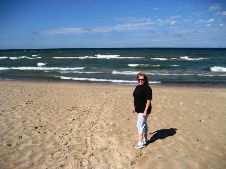
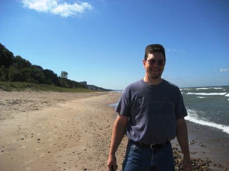
Route A2, which follows the shore of Lake Michigan. Stopped at Van
Buren State Park. No one there. Walked on beach; it was exactly
like an ocean but it was freshwater. It reminded us of Seabrook in
NH, even down to the nuclear power plant (see picture of Josh with
nuclear reactor behind him) Very windy so the surf was up. It even
had amazing (and environmentally/legally protected sand dunes). We
took some pictures, collected some rocks, and ate lunch in the
camper in the parking lot.
Went a little
further north on A2 and came upon Lake Michigan Maritime Museum (see
pictures).in South Haven, MI. No one there. We got the carpenter’s
tour (he was actually a maritime carpenter) of an 1813 cargo vessel
– sails, cannon, etc., which was used in the War of 1812 (for those
of you who are historically challenged, the War of 1812 went from
1812 to 1814).. There was also a lighthouse exhibit that was very
interesting. It was amazing how many lighthouses were on the Great
Lakes. There was a Rescue Boat exhibit which was housed in a real
Coast Guard Surfman’s Station and had on display 3 rescue boats.
The phenomenon of
rich people buying lakefront cottages from the mid-1900’s and
tearing them down to build McMansions on postage stamp size lots
(ala the Lake Winnipasaukee phenomenon) is alive and well here on
the southeastern shore of Lake Michigan. They are also developing
shoreward farms into California style gated communities for the rich
and famous.
We continued north
on A2 to Holland, MI, and went straight to the new Doubletree Hotel
just off Route 31. It was so new, they were still constructing
parts of it. We were checked into the hotel by a gentleman names
“Kraus” – get it? Holland / Kraus. Our room is very nice and has
direct access to the pool, which we immediately took advantage of.
We were the only ones there so we stayed in the water for a good
hour and a half.
We’re hoping that
Josh’s surge protector shows up here tomorrow morning.
Don’t have plans
yet for tomorrow.
That’s all for
now,
-Dee and Josh
Wednesday,
Day #8
Everything happens for a reason…so, we stuck around the hotel room
until noon; but Josh’s package still hadn’t arrived. We decided to
leave and try seeing a few sites around Holland, hoping that the
package would arrive in the early afternoon.
There was a Holland Historical Museum with displays on Dutch
immigrants to the area, but we had to drag the camper through city
streets to get there (having to stop for gas at a corner gas
station). We found a nice long on-street parking site one street
over from the museum. We got out and suddenly Josh stopped, dropped
his head down to the level of the camper tire, and said “Do you hear
that?” I couldn’t, but he insisted that he thought he heard hissing
from one of the camper tires. He got out his new and improved tire
pressure gauge (most gauges only read to 50 psi
and the camper needs 65 and the truck 65/80) and found the tire was
15 psi less than what it should be. We
punted on the museum and took off in search of a tire store in the
middle of the City of Holland! We got very lucky. We saw a police
officer standing by his SUV on one of the residential streets, so we
stopped so I could ask him if he knew how to get to a tire store.
Upon stopping I proceeded to notice that his jacket read “Evidence
Technician” and that he was filling out what I now believe was an
evidence envelope. CSI Holland, MI!? He was very nice and didn’t
seem to mind interrupting his crime scene reporting to let us know
that two block over there was a tire store (see picture). The guys
at the tire store were terrific. They took care of us right away
and were happy to give us the offending piece of road debris that
had punctured our tire.
Having now used up an hour or so, we called the hotel again – no
package. We gave up and headed north to deal with the
package-in-transit at a later time.
About a half hour out of Holland on very scenic shore roads, we got
a call from the hotel – our package had arrived. We made the
decision to turn back and go get it. Interestingly, even though we
asked to have the package sent overnight, the lady from the
campground sent it UPS Ground, and it was only luck that it arrived
today.
So,
at about 2:15 p.m. we again started north again from the hotel…
Heading north again we saw: a 200+ car coal train, acres and acres
of high bush blueberries, another scenic beach front pullout where
we stopped to look at the lake (much calmer today). Then, just east
of Luddington we saw a sign that said
“Amber Elk Ranch, right two miles”. How can you pass up the
opportunity to see an Elk Ranch? They were closed, but we pulled
over and saw some very impressive elk (see pictures) making the
detour worth it. Since we could not turn the camper around on that
road we had to stop some locals on a hay tractor and ask for
direction back to the main road.
Since it was getting late and we didn’t have anything to cook, we
stopped for pizza and onion rings at Papa J’s Pizza and Diner in
Honor, MI – highly recommended if you happen to find yourself in
Honor. Since I (Denise) had blueberries on the brain and since this
area is the fruit capital of Michigan AND since the pie that was
displayed on the counter was blueberry crumb pie – well…I just had
to have a piece. It was delicious.
Pulled into the campground just south of Traverse City at about 8:30
and managed to back in (easy to do when you’re not dodging fire pits
that are holes in the ground) and get set up in the dark in just a
few minutes (Mom – I (Josh) am now sitting in the camper smoking my
pipe – for the rest of you, it is an inside joke).
Heading towards the Straits of
Makinac(?)
tomorrow.
Miss
everyone…
-
Dee & Josh
Thursday,
Day #9 (9/13/2007)
Hi
all,
One
more system tried and found to be in good working order – the gas
heater. It got down to 42.9 degrees last night. We stayed at the
KOA just south of Traverse City, MI. Not bad.
We
began the day traveling north on 37 to Traverse City where we
followed 37 up on the Old Mission peninsula. The road ended at the
top of the peninsula in a park which contained an old lighthouse and
an old settlers’ cottage (see pictures). Riding up the peninsula
itself was interesting – lots of apple and cherry trees as well as
grapes. It appears that this region is a famous wine country.
After getting back down the peninsula to Traverse City, we looked
for a place to have lunch. Traverse City is very touristy and was
rather crowded for a Thursday early afternoon. We got out of the
real thick of things and noticed a purple and blue older building
that looked like the old drive-in A&W ‘s.
It was called Don’s Big Hamburger Drive-In...so,
we just had to stop. It was a real 1950’s car-hop diner with the
original furnishings, 45-rpm jukebox, and waitress – gray thinning
beehive hairdo and all. [Josh: Since they had a real jukebox with
45’s I couldn’t resist. Since I didn’t have quarters, I had to ask
at the register for “change of a dollar for the jukebox” – I’ve
always wanted to say that – Jeff, Ethan??? (Rock This Town by the
Stray Cats]
After lunch we continued north on route 31 to the KOA in Petoskey.
Today is night #4 in western Michigan. Who would have
thunk we’d spend so much time in
Michigan! This place is like the Ritz Carlton of
KOA’s. Golf cart guide to our paved and
level site; back-in assistance; the man
squeegeed the puddle by our door and gave us restaurant info
and a pitch on their food court. He would have delivered the
firewood to our site, but I (Josh) couldn’t see letting a 70 year
old retiree carry my wood. May stay more than one night, we’ll see.
Had
our first campfire of the trip.
While we were sitting by the fire, our site guide Alan drove by in
his hi-tech golf cart and swung into the site to say hi and to point
out that we truly knew how to relax (sitting in our lawn chairs by
the fire with a beer). I offered him a beer, but he declined,
though he then came around again to say that he really appreciated
the offer but that he could not drink while on duty. As expected,
their “one night’s fire” bundle did not last for a full evening, so
back to the store for more wood and, since we had been driving
through cherry orchards all day and there had been a big sign in the
office advertising pies, a slice of cherry pie. This time Alan
would not allow me to carry the wood back myself
so he drove it to the site while I walked back. He was there
chatting with Denise and stacking the wood for us (really, the Ritz
Carleton of KOAs) when I came back to
tell her they were out of pie. Well Alan snapped out his
walkie-talkie “Alan to guest services, The
guests in site 29 were looking for pie, will there be any tomorrow?
Over” “Don’t know what was ordered” “10-4, can you call Gary on his
cell phone and see if there will be cherry pie tomorrow. Over”
I am not making this up. He then stood there and chatted
with us for about five minutes waiting for a response. “Guest
services to Alan, yes Gary ordered pie for tomorrow,
it should be here by noon.”
“10-4, Alan out”.
-Josh and Dee
Friday, Day
#10 (Sept. 14th)
Hello again all,
We
decided to stay another night here at the “KOA Ritz Carlton” – day
#5 in Michigan. Wanted to do some more
sightseeing on small roads, which we can’t really do with the
camper.
As
advised by the campground staff, we headed north on 119 along the
lake shore. There are some amazing homes being built and pretty
much most of the land appears to be for sale as well as many of the
older summer homes. One thing is for sure, there is a lot of money
coming to this part of Michigan (don’t know from where though - ?
California, ? Chicago,
??). At least for right now Route 119 is still very
narrow, wooded, and not very
trafficy. At one point, a small doe was
standing by the side of the road; instead of bounding away, she just
turned to look at us, let me take her picture, and stood there while
I talked to her for a few minutes – her ears perking every time I
said something (see picture). She finally got bored and wandered
off.
Evidently, the area surrounding this particular road used to be
quite a large Indian settlement with some early European fur traders
also making this their home.
http://www.legsinn.com/history.html
There were a couple of old cabins (like we took a picture of
yesterday) just by themselves by the side of the road – no historic
marker or anything.
The
folks at the campground recommended a restaurant part way up 119
called Legs Inn, so we decided to have lunch there. They were
offering Polish fare which was very good. The place itself is
something on the Michigan Historic Register and is rather unique.
Click on this Link
http://www.legsinn.com/
After lunch we continued north on 119 and turned into the Sturgeon
Bay Wilderness Area. There was a turn out about a mile down this
road where we pulled over and walked down to Lake Michigan. This
time I put my hand in the lake and got hit with an incoming wave – a
little more wet than I wanted to get on a cold, raw day. Oh well.
A little further down that road, we ran into a storm coming off the
lake and it began to hail.
At
the end of Route 119 we hooked back up with Route 31 north into
Mackinaw City, which is where the Mackinac Strait goes through from
Lake Michigan to Lake Huron with a very large bridge (which we’ll be
crossing tomorrow) that goes over to the upper peninsula of
Michigan. They are recreating through an archeological dig Fort
Mackinac – it was closed by the time we got there, so just took some
pictures from outside. (see pictures).
See this link -
http://www.mackinacparks.com/parks/fort-mackinac_6/
We
then followed Route 23 south along the shores of Lake Huron for
about 50 miles. We stopped at a pull out and walked down to that
lake. I again put my hand in the water and got hit by a small
wave. Didn’t get too wet.
When
we got back to the camp ground, the cherry pie was waiting for us
J
Heading out towards Green Bay, Wisconsin tomorrow a.m.
-Dee
and Josh
Saturday Day
#11 (Sept. 15)
All,
There are two words that really get the attention of RV service
people… propane leak. We decided to get an early start this morning
because it looked like a long driving day. We decided, with the
weather cold and getting colder, heading up into the Lake Superior
shore of Ontario might not be a good idea. Instead, we decided to
head across the upper peninsula (aka
U.P.) of Michigan and down into Wisconsin to Green Bay.
While I was hooking the camper back to the truck and getting ready
to leave, in the back of my head I was still trying to diagnose
Denise’s “Do you smell that, it smells like poop” concern. I had
been checking the waste tanks and valves and everything else I could
think of but couldn’t come up with anything. I could occasionally
smell what she was complaining about but couldn’t figure our where
it was coming from. Well I finally figured out that it was coming
from near the area where the valve is for the external propane grill
connection. When I stuck my head under the
camper there, lo and behold, another hiss. I shut off the
propane tank and the hiss stopped, turned it back on and the hiss
started again. So off to the local RV dealer, who was “kinda
busy today, so…” until I mentioned that it was a propane leak. Then
it was if you can be here in 15 minutes we’ll squeeze you in. The
folks there were very nice and we got the leak fixed (turned out to
be a cracked brass fitting so Denise will be giving an earful to the
Starcraft warrantee department on
Monday), and the propane system pressure tested, and we were on our
way. At 12:30 again, even though we had tried for an early start.
We
crossed the bridge over the Mackinac straits to the
upper peninsula -- for those of you from
NY, think of crossing the Verranzano
Narrows bridge, towing a camper on a windy day. The U.P. itself was
nice, and a lot less built up than the rest of Michigan.
Late
afternoon we crossed into Wisconsin, the central time zone, and a
land of under $3.00 per gallon gas. Hallelujah!
We
did not have definite campground plans and called one place that
sounded good that was part way between the U.P. and Green Bay.
However, since we were making good time, we wound up canceling that
and heading to a campground past Green Bay in a town called Kewaunee
on the shore of Lake Michigan. Since the map of Green bay was not
that helpful, we wound up driving right through downtown. It was a
little challenging, but not too bad, though we did have to stop for
a raised drawbridge and some of the road paving was pretty bad.
There were two sections of road that had bumps between pavement
sections every six or eight feet and seemed exactly in sync with the
distance between the truck and camper wheels, which set up a pretty
wild bouncing.
Made
it to the campground in Kewaunee just before the office closed, our
first non-KOA, and had a nice long chat with Warren, the owner,
about the Good Sam RV Club, the evils of KOA, his life after
retiring from the Air Force, Dorr County, his one visit to New
Hampshire, and a bunch of other things that I can’t remember. About
an hour after arriving we were at our site.
It
appears that we’ve arrived in Wisconsin to record cold overnight
temperatures – glad we know the heater works.
-Josh and Dee
Sunday, Day
#12 (Sept. 16) - Go Pack Go!
Hi
all,
Decided to stay in Kewaunee and take the day to go into Green Bay.
If you remember, from last Sunday’s trip log, we mentioned meeting a
couple from Wisconsin (while we were at the Football Hall of Fame)
who told us that we may be able to get a tour of the stadium where
the Green Bay Packers play. Although I (Denise) am a Patriot fan,
my 2nd favorite team has always been the Green Bay
Packers. So, we took the half-hour drive back to Green Bay and
found the stadium without much problem. We already knew that they
were playing today at the Meadowlands against the Giants. A gate to
the parking lot at the back of the stadium was open, so we took a
chance and drove in. We drove around and found the main gate, so we
parked and walked up the steps. From the outside you couldn’t tell
whether it was open or not, so we tried one of the doors. Sure
enough, it was open. We walked into an area where there was a gift
shop, pro shop, ice cream shop, and the entrance to the Packers Hall
of Fame. They were offering tours of the stadium each hour, so we
signed up for the noon tour. It was awesome. They just completed a
mega renovation by adding a 4-story atrium that is open to the
public 364 days of the year except when the Packers have a home game
and on Christmas. There are pubs, restaurants, function areas (you
can actually have your wedding there), corporate meeting areas, and
more. We got to sit in a luxury suite, then
we got to walk down the same walkway that the players enter the
field from, and then we got walk on the field and sit in the
stands. I found it amazing. I walked on the same ground that Bart
Star and Bret Favre walked on! I felt
this awe once before when Josh & I visited Boone Plantation in South
Carolina (1992) – they were using the plantation for the filming of
the mini-series “South” and Patrick Swaszey
had walked on the same floors that we were walking on!
The
Packers Hall of Fame was on par or better than the Football Hall of
Fame. The Boston teams should do something like this; it could be a
healthy revenue generator. We ended up having lunch at
Curly’s Pub (named after the famous
player/coach Curly Lambeau, for whom the
stadium is named) and watched the game on TV with all of the Packers
fans. (See pics of visit to
Lambeau Stadium)
Back
at the campground, god forbid a day
should go by where we don’t have to learn another “system”. We had
problems with using the “gas hot water heater” option (as opposed to
using electricity to heat the water, which is what we’d been doing
so far). We decided to use the gas option to see if it would help
with having hot water long enough to take a “full” shower, which
really doesn’t happen with electricity heated hot water. It really
didn’t seem to make that big of a difference; however, it did manage
to cause a leak under the sink and also the hot water tank was
making “funny” noises. Josh found the source of the leak right
away. I’ll let him tell the story… The issue was that with added
heat from the gas heater additional pressure built up in the hot
water tank (I think that is Boyle’s Law). The pressure caused a
small leak in the one of the connections (easily fixed by
tightening) and caused the pressure relief valve to open and let
some water out (Denise’s funny noise). After reading the manual I
managed to reestablish the air pocket in the tank that cushions the
pressure and everything is running fine now. We also figured out
how to get the powered antenna working better and so we were able to
get HD channels off the air, so we could watch the Patriots game in
HD.
Overall a great day in Green Bay!
-Dee
And Josh
Monday, Day
#13 (Sept. 17) - Manitowok
All,
We
decided to stay in Kewaunee one more day and get caught up on
laundry (7 loads to be exact), get the Chevy’s first oil change &
tire rotation (there was a Chevy dealership right on Route 29), and
then see some of the local area.
First a little morning excitement (or chill) when we ran out of
propane.
We have two 30 lb tanks and the explanation we received when we got
the camper about how the switchover valve works turns out to have
been completely wrong. As a result, when the first tank ran empty
it did not switch over to the second. Once again, we have figured
out how things actually work, as opposed to how we were told they
work; and we are all set. The guy in the camper next to us, and
Warren the campground owner, were both very helpful as well.
After lunch we headed out to Manitowok
to see the Wisconsin Maritime Museum. Part of the museum was the
submarine “Cobia”, which saw action in WWII and was a training ship
during the Korean War. As it happens,
Manitowok (a big shipbuilding hub on the Great Lakes) was
retooled to build submarines during the War. They produced 28
submarines of which 4 were lost during the War. This is my 3rd
sub tour (previously one in Fall River, MA, and The Albatross in
Portsmouth, NH) a Josh’s 2nd (The Albatross). It never
ceases to amaze me – the space is so confined, hot, and smelly; and
there are so many dials, valves, switches – the correct use of which
may mean the difference between life and sinking. For those of you
who didn’t know – Charlie’s brother Gerard served as a submariner
during WWII. The museum itself had wonderful displays of old wooden
boats that traveled the Great Lakes; ship models (some were 5’
long); shipwrecks; fishing; shipbuilding; goods that were traded on
the Lakes; etc. We ended up spending about 4 hours there.
As
we were leaving, a thunderstorm passed through on its way out onto
Lake Michigan (as a point of orientation, we are now in eastern
Wisconsin, which is the western shore of Lake Michigan). The road
we took out of Manitowok followed the
shoreline. The waves breaking on the shore were impressive (locals
were pulling over and snapping pictures – so did we [see
pics]) and the lightning show out on the
Lake was rather impressive. At one point, we had pulled over to
take pictures and the lightning hit the lightning rod on a light
house right in front of us. Got out of there
rather quickly.
Drove around some more looking at the countryside.
Drove half way up the Door peninsula
looking for a restaurant, but all we seemed to find were what
Charlie used to call “beer joints” – picture
Blackies under the overpass. Needless to say, we didn’t stop
at any of them. We ended up coming all the way back to Kewaunee and
ate at the only restaurant we could find open. Josh was
jonesing for a traditional whitefish
dinner after spending a day in the Maritime Museum and looking at
all the display of fish that can be caught on the lake, so
McDonald’s wouldn’t do.
Hope
to head out early tomorrow and put some miles behind us.
We’re going to miss Lake Michigan – she’s been with us for about 8
days now.
Dee
& Josh
Tuesday, Day
#14 (Sept. 18) - Whose idea was Iowa?
All,
This
morning we got up; both took showers; emptied the black, grey and
galley water tanks; rehooked up the
truck to the camper and were still on the road by 10:30 (though we
did have some help from the fact that we are in the Central Time
zone). That was the good news. The bad news was that when deciding
where to head today, since it is still cold up in Canada and since
there were supposed to be storms in northern Wisconsin, Denise said
the fateful words…. “Let’s go to Iowa. Then I can say I was in
Iowa”. So off we headed to the southwest.
Problem number one, was that the direct
road from the Green Bay, WI, area to the northeast corner of Iowa,
route 151, turned out to be the worst paved road that either of us
had ever been on. We had had a few problems previously in Wisconsin
with roads that seemed to have bumps in sync with the truck, but
this was so bad that after about a half hour we had to give up and
get off the road. The truck and the trailer were bouncing so much
that I (Josh) was getting very nervous that the hitch was going to
come loose. Normally, I don’t use the rear view mirror while
driving because all I can see is the front of the trailer (for those
of you – Mom – who are worried at this point, I have extra wide side
mirrors). However, I kept looking in the rearview mirror and I
could see the trailer going up and down. Meanwhile the truck was
riding like a boat in choppy seas. So we got off of 151 in Beaver
Dam, WI, and dead reconned our way on
back roads to route 60, which was a smaller road, but much nicer to
drive on and with much better scenery to boot (see pictures of
cornfields as far as the eye can see). Overall we wound up going
faster on the back roads because we were not fighting the bumping;
although there was a pretty stiff headwind pretty much the whole way
from Kewaunee.
At
5:33 PM CST we crossed the Mississippi river into Iowa and are now
officially WEST! (See pictures)
At
5:47 PM CST, we came around a bend in the road by a rise in the
corn, and drove into a scene straight from the movie “Twister.” The
attached pictures do not really do justice to how threatening the
sky was, but there was really no where to turn off and we had a
tractor trailer behind us. Within a few minutes we were driving
right through the heart of the storm, the rain was so hard that it
was nearly impossible to see, and the wind was jarring the truck -
we were down to about 20 MPH; and Denise was hyperventilating and
was convinced that we would be sucked up by a tornado at any
moment. The only thing that kept her from totally freaking out was
the fact that cars were coming (albeit slowly and infrequently)
through from the other direction. Although it was good to see they
made it through, we now needed to be worried whether they were on
their own side of the road or not – there basically was zero
visibility beyond a foot or so. We got through safely but very
shook up. With still no where to turn off to recoup, we just drove
on to the campground in Clermont, IA, which was about 20 minutes
further. The lightening and rain continued but at a “normal” rate.
When
we got to the campground, we noticed the sky to our west was again
very dark and threatening. We went to check in and asked the woman
how they know the difference from a “regular” thunderstorm and a
tornado. Instead of saying “Oh, don’t be silly, we don’t get
tornadoes” she said, “When the sky gets really green we know a
tornado is coming and the barn (pointing to a building that looked
pretty far away if you have to run to it during a tornado) has a
sturdy foundation so just get in to the bottom floor and you’ll be
fine”. She also mentioned having her own key to a storm shelter,
though she didn’t offer up the key or the location of her “secret”
storm shelter.
So,
we went back out to the camper and took a pull-through site and left
the car and trailer hitched together. At this point, the
threatening sky to our West was now over our heads. Poor Josh let
me into the camper while he hooked up water & electric and
stabilized the camper. We tried to connect to the internet to get
weather radar info, but the internet connection appeared to be
down. We tried the TV but got no reception.
So, not knowing if we were in for another “tornado” Denise proceeded
to crawl up on the floor in the bathroom/hallway area and waited
anxiously (to put it mildly). The storm had a lot of rain
and lightening but, thankfully, no wind and no freight train sound –
there, in fact, does happen to be a train track in current use right
across the way, so don’t know how helpful that warning would be to
us.
Poor
Josh, again, had to go out in the rain to hook up cable because
Denise wouldn’t calm down until she knew what was happening with the
weather.
We
did get cable TV working, and yes they were predicting rather stormy
weather for this area tonight, but thankfully no tornados.
Not
sure how good we’ll sleep, but we’re exhausted. Today was not a day
we want to repeat.
I
can now say that I’ve been to Iowa and will be leaving first thing
in the a.m. never to return.
Josh
& Denise
P.S. – We’ve had poor luck with internet connections, so you’ll
probably get this as well as the last 3-4 days worth of diaries.
Please don’t panic (Mom) if you don’t hear from us for a few days at
a time.
Day #15, Wed
(Sept 19) -- Little House on the Prairie
Hi
all,
Well, we survived the night here in Clermont, IA.
A few more T-storms with lots of rain but no big
winds.
Decided to head northwest out of Iowa and into southwestern
Minnesota toward Walnut Grove.
For those of you who don’t know what Walnut Grove is, it is the
place depicted in the TV series “Little House on the Prairie” based
on the Laura Ingalls Wilder books.
Shortly after we crossed into Minnesota on Route 56 in
Taopi, we saw our first “wind farm” with
rows of big white wind turbines in cornfields (see
pics). We found Minnesota to be much
flatter than northeast Iowa. Also, in Minnesota, along Route 218
which followed a railroad track, there were abandoned telegraph
poles which are shorter than today’s utility poles. There were no
wires strung between them, but some of them still had insulators at
the tops of the cross pole. We couldn’t find a place to pull over
to take a picture though.
Of
course, a day can’t pass without a technical issue with the camper.
Today’s issue was a broken rear light. When I say broken, I mean
BROKEN. Josh was walking back to take a picture of “Route 14 –
Laura Ingalls Wilder Historic Highway”,
so he put the flashers on to warn drivers we were pulled over. He
noted the light was out, so he took the protective cover off to find
the bulb glass had split into two pieces! It was fine when we left
Kewaunee, WI, because I remember doing a “light” check. It must
have broken when we were driving over the rough roads yesterday!
Since this meant that our right turn directional wouldn’t work, we
decided to fix this right away. Couldn’t find a car parts store;
however, once again, we were forced to pull into a
WalMart. They did have the bulb we
needed, so Josh replaced it and we were on our way.
I
wanted to see the towns mentioned in the Little House series –
Mankato, Sleepy Eye, and Walnut Grove. They are all in a line along
Route 14 spaced out evenly over a 75 mile stretch of road –
appropriately named The Laura Ingalls
Wilder Historic Highway. We arrived in Walnut Grove rather late –
7:00 p.m. There really is nothing there except a huge grain
elevator and a few houses and, as far as we could tell, a large
population of Asian Americans! Walnut Grove has a population of
under 600 people. We located Plum Creek,
obviously not the paradise of a waterway that it probably was in the
1870’s. We also located the Walnut Grove cemetery. The only name
we could find that I recognized from the series was Hansen (as in
Lars Hansen who was depicted as the founder of Walnut Grove in the
series). There was a tiny museum, which obviously was closed; but
it didn’t seem to be very big. My research found that there is a
good size museum in Missouri where Laura and
Almonzo moved to raise Rose. We’ll try to hit that when we
get to Missouri in mid-October. Josh also found (on Google) the
Wisconsin location of Little House in the Big Woods, but we’ve gone
too far west to go back now. But his research did show a site in
South Dakota that we may try to get to (although I don’t remember
South Dakota being mentioned in the Little House Series but
evidently it was a big part of the book series).
Since there was no place to stay in Walnut Grove, we decided to push
on to what Woodall’s promised was a 5* campground as part of a
casino resort in Granite Falls, MN – about 75 further north from
Walnut Grove. We had no choice – there is nothing up here on the
prairie but fields and fields and fields of corn and soy beans. The
grain elevators here are huge and there is a lot of movement by
semi’s of tons and tons of these crops, which are earnestly being
harvested as we drive by. We stopped at a hole-in-the-wall gas
station in Lamberton (on Route 14 just
east of Walnut Grove) and got to talking with the man behind the
counter. He explained what was in the humongous
grain elevator across the street – corn and soy beans. He
mentioned that that particular elevator (one of hundreds in
Minnesota) processed 120 railroad cars of crops per day!
Most of it going to China, Japan, and other
Asian countries. I asked where we get our corn, and he said
“from here…there’s plenty.” While we were chatting, a young man
(about 18 and named Josh) came in. He was introduced as “This young
man’s family has 4000 acres here.” He noticed we were from NH and
said, “You have farming there don’t you.” We said, “Yes, but
probably a large farm in NH would have about 100-200 acres.” They
all laughed and said, “We call that a Hobby Farm.” All in all it
was a very pleasant interchange.
After driving about an hour through the dark prairie passing semi’s
and collecting bugs on the windshield, we came upon a giant video
sign out in the middle of nowhere, marking the entrance to the
Prairie’s Edge Casino and Resort and the Upper Sioux Reservation.
This is the weirdest place we have stayed so far. The Casino,
Hotel, and Convention Center building is a large, neon-lit,
monstrosity literally in the middle of corn and soybean fields in
the middle of nowhere off a county road off another county road off
a secondary state road. It has its own gas station and convenience
store and then next door is the nicest, neatest, most well
maintained RV campground we have seen. Each site has a huge
concrete pad for the camper, a little manicured lawn, a picnic area,
a brand new fire ring with stone base and grill, and bark much and
decorative bushes around the water and electric hook up. There is
practically no one here and it really doesn’t feel like a campground
at all. Very surreal. Since we came in
after hours, security drove out and wrote down our license plate
number. (Denise had called and George said he would reserve a spot
for us – but then he taped the map with directions to our site to
the INSIDE of the locked office door).
Well
were safely here for the night. More adventures tomorrow.
-Denise and Josh
Day # 16,
Thurs (Sept 20) -- "Oh Toto..."
Hello everyone,
7:30
a.m. – The rumble of distant thunder. Oh, no!
not again…Josh grabs the computer from the bedside and checks
the radar. Line of storms running from southwest to northeast but
looks like it’s probably going to go north of us. Get up and start
getting ready to leave.
8:30
a.m. – Knock on the camper door. A nice gentleman from the tribe
tells us…”We’ve been issued a tornado warning. One was seen 20
miles west of here. Just wanted to let you
know. We’ll sound a horn and the tornado shelter entrance is
at the back of the bath house (pointing to a building about 75 yards
away.” We say, “Thanks.”
8:35
a.m. – Walked over to check out where exactly the door is. Don’t
want to have to find it in a blinding rain. A few more couples join
us. It’s starting to get very windy, so we all just huddle around
the door which leads down to an underground bunker. We all hang out
there for about the next 45 minutes…watching the clouds come
over…watching the wind keep changing directions…and trading tornado
and camper horror stories. Finally, one guy says “Well I’ve had
enough. I’m rolling out of here.” And off he
and his wife go. The other older couple sticks around for another
few minutes and then they decide the same. We figure, well we may
as well too.
9:52
a.m. – We’re heading out toward Duluth, MN, to see Lake Superior.
Josh wanted to wait a little longer to let the storm (which is
heading in the exact direction we’re heading) get far enough ahead
of us that we won’t run into the back of it. I didn’t feel like
playing the slots at the Casino, so I kinda
wanted to get moving. So, off we headed northeast on Route 23.
About an hour up route 23 we ran into the back of the storm. We
pulled over in front of a little mall to decide what to do next.
While we were discussing it, the storm which had been moving
northeast turned east south east and came right towards us. The
lady in Iowa said you can tell when there is a tornado coming
because the sky turns green. So when the sky started turning green
we decided we needed to drive away from the storm.
We
headed south and west on back roads and drove through some strong
rain but nothing worse. We luckily found a good local AM radio
station (Minnesota Farm Network) and between soybean futures reports
they kept us up to date on the progress of the storms through
central Minnesota, including damaging wind, nickel sized hail, flash
flooding (4” of rain in a very short period of time at one place we
stopped), and several tornados. So as I was driving, Denise was
studying the map against what the radio station was telling us and
navigated us around the tornadoes and hail. Every time we stopped,
the locals were all talking about how bad the weather was and how
they hadn’t seen a day like this in a while. We were still hoping
to get to Duluth so we could see Lake Superior, but the route we
took to avoid the storms resulted in going west then north then east
to go northeast and probably added about 150 miles to the day.
When
we arrived in Duluth, they were still predicting some serious
weather overnight. So, instead of staying in a campground we opted
for the Country Inn and Suites outside of Duluth. It was about 7:45
p.m. by that time, and we were lucky to get one of the last 3
remaining rooms. I must admit that the prospect of a real shower
(and Denise needed to shave her legs again!) played a little role in
choosing to stay in a hotel. This way we can drive into the city
and along the lake without towing the camper.
-Dee
and Josh
This
is what the sky looked like when we first stopped at the shopping
center. By the time we left, it had shifted right over us and
lightning was coming out of the clouds in 6 or 7 places at a time
and it was hitting very close to us. The rain was coming down in
buckets. I’ve (Denise) never “flown” out the back of a storm, but
it was quite an experience dodging this monster storm.
Day #17,
Friday (Sept. 21) - Unexpected Duluth
All,
Close your eyes and picture Duluth, Minnesota – cold, blue collar,
industrial, dirty… That is roughly what we expected this morning as
we set off to see the city. The only bright side was that, since
the hotel was nice and we were both a bit worn out from driving over
1100 miles in the last three days, we decided to stay an extra day
at the hotel. Since we are staying north of town, we unhooked the
camper at the back of the hotel lot and just took the truck in to
see Duluth and maybe drive up the southwestern shoreline a bit. As
we came over the hill and could see the city, it was bathed in fog
and smoke and looked exactly like we expected. However, when we got
off the highway and into downtown, Duluth turned out to be a great
city.
We
drove past a giant General Mills grain elevator (where Cheerios come
from), another maritime museum with a coast guard cutter and a
freighter, and the aquarium which we may go back for.
Glensheen
Mansion -- Driving north out of town we passed a sign that said
historic home tours next right. Denise immediately wanted to pull
in, so we did and stumbled onto the most famous Duluth tourist site,
run by the University of Minnesota with tours given by students. (http://www.d.umn.edu/glen/
). It is a mansion build on 22 acres on the shore of Lake Superior
from 1905 to 1908 by a coal baron for his wife and 7 children. Over
the years, the acreage has decreased to about 7 acres. The house
itself was amazing. They wouldn’t allow pictures of the interior
and the website doesn’t have any interior pictures either. I guess
you’ll just all have to visit Duluth once in your lifetime and see
for yourself. Sorry. The grounds were gorgeous. We learned from
one of the other visitors who happens to
be from the Minneapolis area that there was a murder there in 1977.
It appears that the last remaining daughter, who was still living in
the mansion with her nurse, was murdered (along with the nurse) by a
relative who was looking to inherit the entire estate.
We
continued on up the shoreline and discovered Two
Harbours which had some old trains on
display and a giant ore freighter that was being loaded and getting
ready to depart (see pictures). Continued up the shoreline of Lake
Superior and I (Denise) did get to put my hand in Lake Superior, but
this time I didn’t get soaked from the waves. There were also some
neat tunnels carved into cliffs that you had to drive through. All
in all it was well worth the ride. Wish we had time to go further
north into Grand Portage and then on to Thunder Bay (Ontario), but
that will have to be for another trip.
Grandmas (http://www.grandmasrestaurants.com/
) – The same couple who told us about the murders at
Glensheen, also told us about a landmark
restaurant in the waterfront area of Duluth. Apparently, the
restaurant we ate at is the flagship location. The atmosphere was
carnival; the food was awesome; the waitstaff
were very efficient and professional; and it was a lot of fun.
Evidently, wild rice if very popular up here in Minnesota as is
freshwater fish, so we decided to immerse ourselves in the culture.
The chicken & wild rice soup was out of this world and the walleye
http://www.pvisuals.com/fishing/species/walleye.html
served with wild rice and steamed carrots and broccoli was terrific.
The
sample couple we met at Glensheen also
told us about some places to see in South Dakota, so we’ve included
them on our itinerary when we get down there. This is the 2nd
couple we’ve met while at a “tourist attraction” who have been very
helpful with recommendations for things to do further west (remember
the couple from the Hall of Fame who recommended
Lambeau Field tours).
Overall, we are loving Duluth.
Josh
& Dee
Day #18,
Saturday (Sept. 22) - Minnesota's North Woods
All,
Today we checked out of the hotel, but left the camper in their
parking lot and took one more trip into Duluth to go to the
aquarium. Denise found the aquarium disappointing, though I thought
it was OK. However, being an engineer, I had the most fun helping
the kids with a room-sized model of the great lakes and the lock
systems that get boats from Superior to the Atlantic. [Denise:
Josh was having a good time teaching the kids how to use the locks;
however, I noticed the moms were getting a little nervous – a grown
man interested in children – in this day and age, sadly, people
think the worst].
Then, back to the hotel to reconnect the camper and off to Bemidji.
MN. We drove for about three hours through northern Minnesota,
through open forest, swampland, and lakes. Interestingly we also
crossed the Mississippi river two or three times today, though up
here it is really only a stream. We are not too far from Lake
Itaska which is the source of the
Mississippi. The campground in Bemidji is likely the northernmost
point on our trip. It is fortunately unseasonably warm here this
weekend so it shouldn’t get too cold tonight.
All
in all, today was a rather noninteresting
travel day.
-Josh and Dee
Day #19 -
Sunday (Sept 23) - More Minnesota...
All,
One
more technical issue this morning.
I had been meaning to check the tire pressures for a while and I
finally got to it this morning before we left. As soon as I checked
the first truck tire I knew that we had an issue. The truck’s specs
call for 60psi in the front tires and 80 psi
in the rear. Apparently when we got the oil changed and the tires
rotated back in Wisconsin they swapped the front and rear tires but
did not change the pressures – you would think that since it is
spec’d by Chevy and it was a Chevy
dealer they would have known what to do, especially since we are
definitely in truck country. Oh well, it is something that I will
know to make sure of in the future. So our first stop was a local
gas station to get the tire pressures corrected. It did help
somewhat with the bumpiness we had been having, but not enough to
think that the roads in Wisconsin didn’t suck!
Then
we decided to head into Bemidji since we had passed it on the
“highway” last night. We followed the signs to town, but as best we
could tell there really was no town. There were two strip roads
with big box retail and trailer parks and manufactured housing in
between. But nothing that looked like a real town. If it was there
we couldn’t find it and we drove around for a while looking.
Then
we headed south and since we were looking for a challenge before
lunch, we pulled over, took off our shoes, rolled up our pants, and
walked across the Mississippi River. Really! Look
below, there are pictures of Denise and I
walking across the Mississippi. This was in Lake Itasca State
Park. Lake Itasca is the source of the Mississippi and they have a
very nice set-up and a short walk through the woods to the point
where the Mississippi River flows out of the lake. Of course at
that point it is only a few feet wide and a few inches deep. It
will be interesting when we get to St. Louis to realize that we
walked across the same river.
Drove west to Fargo.
We were contemplating staying there though the weather reports were
calling for potentially severe weather in the Fargo area. The
further west we went the hotter it got and the stronger the winds
got. There was one gust that really got the trailer swaying until I
got it back in line (Denise: Josh is understating this, it was a
pretty scary few moments). By the time we got to Fargo the
temperature was near 100 and the winds were really whipping.
Frankly, other than the nice new bridge over the Red River (needed
replacing after the great Red River flood of the spring of 1997)
there didn’t seem to be much to see. We decided to head south to
avoid any potential weather. There was a good looking campground
listed in our guide in Ortonville, MN and it was part of the way
towards De Smet, SD which is where one
of the other things we want to see is (more on that later).
The
drive was long and, since we were going into the wind the whole way,
it was like driving up hill for two hours. Back on the prairie so
there was not much to see. I think there was at least one half-hour
stretch where we were the only car on the road! The campground is
nice and for the first time we are parked right on a lake (Big Stone
Lake). The campground is almost empty as this is the last week of
the season for them so we have the whole lakefront to ourselves.
Since we had nothing to cook, we went into “town” and had dinner at
the Matador Supper Club. The food was not great, but it was Sunday
night so they had the polka band in and the old people were all
dancing - which was fun to watch.
-Josh and Dee
Day #20
Monday (Sept. 24) - Walnut Grove Redux
All,
Neither of us slept well last night so we got off to a late start
this morning. We decided not to push it and to stay here in
Ortonville, MN, another day, so we headed out for a ride at about
1:30 p.m. Looking at the map, we realized that we are really not
that far from where we had been in Minnesota a week ago (we really
have done the circuit tour), and before long we were headed back
towards Walnut Grove with the thought of catching the museum before
it closed this time (5:00 p.m.)
Well, true to form we showed up at the museum in Walnut Grove at
4:30 p.m. The woman asked where we were coming from, so I told her
the story of how we were here too late last week, so we found
ourselves in the area today and thought we’d try again. Being from
New Hampshire, we’d probably never get back here…she was very nice
and let us do a whirlwind tour of the museum buildings FREE (it was
only $5 admission anyway)! Unfortunately, there was much more there
than one would have guessed just by looking at the outside. We did
our best to make sure we saw the important things – a picture of
Charles and Caroline and their children; a chronology of their
lives, including births, etc.; lists of different places in the
Midwest where they lived; and some artifacts that were either theirs
or were part of Walnut Grove’s history (i.e., the original
switchboards installed in 1903). One news article mentioned that
there was actually a sign marker where the
Ingalls’ property was. So, on our way out, we asked the lady
where it was. She gave us a map and told us to head North on
country road 5. Luckily, Walnut Grove is so small we found the road
no problem. We got to the sign and started up what we thought was a
dirt road – it turned out to be a driveway to a farmhouse.
Confused, we backed out. I called the museum (luckily someone was
still there) and asked them if we were allowed to go up the driveway
or what. She said sure; there was a box to deposit an entrance fee
in further along the driveway and then to keep going to the site.
So once again we headed up the driveway which wound through their
front yard and cornfields; and, sure enough, there was the box (see
picture).
The
site itself was basically a parking lot with paths through prairie
grass and wildflowers. At the end of or along each path were
plaques explaining what had been there during the
Ingalls’ time. Most notable was the
spot where it is believed their original “dug out” had been; it had
caved in long ago. A dug out is a one room “house” cut into the
side of a hill with a sod front wall; which is different than a “soddie”
which is four walls made of stacked sod. Plum Creek was right down
the hill from where the dugout was built. Basically, they could
walk out their front door and 20 feet down the slope was the creek.
It was quite interesting; and, if you looked off into the horizon
of fields upon fields, you could imagine what they had seen while
they lived there. I couldn’t resist running down the hill of
prairie grass and wildflowers (just like in the TV series). (see
pictures).
It
was well worth the trip back there.
That
was about all we did today.
Tomorrow, hopefully, we’re off to the next place that the
Ingalls lived – De
Smet, SD.
Dee
& Josh
Also
see the youtube video at
Little House on the Prairie (you have to have seen the show to
really get this)
Day #21
Tuesday (Sept 25) - Little town on the prairie
All,
Welcome to Eastern South Dakota. While checking out of the
Ortonville, MN campground this morning we met the mother of Steve --
the owner who reminded us of a cross between Wayne Haskell, Tom
Connor (from Roseanne) and David Lee Roth. Unlike Steve who was so
busy loving life and being friendly that he didn’t actually say
much, his mother had a lot of useful information for us when she
heard we were headed for South Dakota. She suggested several places
to see along the way.
We
headed out, crossed Big Stone Lake into South Dakota, and headed for
De Smet which is our first stop in SD
and the site of Laura Ingalls
Wilder’s Little Town on the Prairie --
It turns out that we are going to see several of her sites since we
are going to wind up in several prairie states before we are done.
After De Smet, SD we are planning to
eventually see Independence, Kansas (Yes Cathi we are probably going
to Kansas) and ??? Missouri
Independence, KS, is the site of the actual little house on the
prairie of Laura’s books.
Never know what you’ll see on the road: So we’re driving along on a
2-land blacktop in SD and we came over a small rise and got stuck
behind a house. This is not a trailer mind you but a full-sized,
two-floor house driving down the road. It was slightly wider than
both lanes of the two lane road we were on, so there was no way to
pass. The good news though is that unlike the house moving that you
see on TV where they creep along, this guy was going about 35 MPH.
The really good news was that we were behind him, not coming the
other way. It was wider than the road and not stopping for oncoming
traffic, which meant that everyone coming the other way was pushed
off the road and had to be careful not to overturn into the 10-foot
ditches that lined the road. [See picture #2 –
notice the house and the lights from an oncoming car that was
forced to the side of the road.] I don’t know what we would have
done with the camper, because he wasn’t stopping for anything.
Anyway, decent driving through the state roads in SD into De
Smet.
Stopped for lunch with the locals at the Ox Bow Restaurant which was
established in 1976 (still in 70s motif, especially dark paneling
and harvest gold counters) and is an establishment that capitalizes
on the “Little House on the Prairie” series (which aired in 1974).
Then off to the site of the Ingalls’
homestead.
Denise on the visit: Again, it was “spiritual” to walk on the same
land as the Ingalls. This was Mr.
Ingalls’s quarter section which is a
half-mile x half-mile square. This is really high grass prairie
land here. The Laura Ingalls Wilder
Society manages the property and they’ve done a tremendous job of
replicating life in the late 1800’s here in South Dakota. They had
a settler’s home, a dug out (see me cooking – those are sod walls
dug into the ground – actually really creepy), barns, sample
gardens, planted fields, the well and pump, a one-room schoolhouse,
and a church. There was so much to see at this site, that we didn’t
have time to actually take the tour of DeSmet
itself, where there are Ingalls’
historically significant buildings. They made it easy for
a visitor to imagine herself back in
1879. It was an experience I’m so glad I had a chance to do.
From
there we headed south to Mitchell, SD which is where the next
campground was and also the Corn Palace that Steve’s mom (see above)
said we had to see. We dragged the camper down
main street in Mitchell and pulled over across the street to
see and get pictures of the Corn Palace (see pictures). It was
impressive in a “why would you do that” sort of way. I guess there
is not much entertainment in Mitchell, SD. We stopped for groceries
at a big store across from the Wal-Mart
Supercenter (does supporting the competition make up for our
few forays into Wal-Mart?). We haven’t shopped for food since the
Piggly Wiggly in Kewaunee, WI so we have
been eating out too much and both of us were getting sick of it.
BBQ steak for dinner tonight! [One note: we are now in the corn
capital of the world, home of the famous corn palace, we’ve been
driving through million acre corn fields for days,
do you think we could get two decent ears
of corn at the store for dinner??? Noooo!!!
We looked and looked in the vegetable section and eventually found a
few lame looking ears of corn stuck between the broccoli and the
Brussels sprouts. The only thing we could imagine was that for
people who work all day growing, harvesting, and processing corn,
the last thing they want to eat for dinner is more corn.]
We
had a choice of two campgrounds in Mitchell and chose the non-KOA
this time and we seem to have made a good choice. This guy is the
only family run campground left in the area and he is doing a good
job. The place is clean, level, wooded, etc. The only concern is
that this is his last week in operation (so the store is mostly
empty – we got the third to last bag of ice). We are clearly
starting to run into the end of the season and several of the sites
we looked at for Wyoming and Montana are closing after this coming
weekend. Fortunately, if we make it that far, the big sites around
Yellowstone seem to be open; and, looking ahead, it appears that
most places in Colorado are open year round (“weather permitting”) –
it looks like they take their camping seriously in Colorado!
-Josh and Dee
Day #22
Wednesday (Sept 26) - Anitques
"Roadhouse"
All,
South Dakota up to today – Grass, corn, soybeans, sunflowers, and a
few roads – including Interstate 90.
Incessant wind!
Left
Mitchell at elevation 1293 on Interstate 90 and 40 miles later
were at elevation 1700! Needless to say,
this long climb was slow going pulling the camper, especially with a
steady stiff headwind.
Stopped for lunch at a combination rest area / Louis & Clark
Exhibition overlooking the Missouri River (see pictures).
Evidently Louis & Clark stayed for some time at Camp Pleasant which
was on the opposite bank of the Missouri. We went to walk down a
path to get a better view of the Missouri; however, the sign “Beware
of Poisonous Snakes” kinda gave us pause
and we turned back.
Once
we crossed the Missouri River and climbed out of the river valley,
the landscape and tenor totally changed. First of all, there is now
only one road – Interstate 90. Secondly, from looking back at the
map, it appears that about 70% of South Dakota is divided into
various Indian Reservations for the Sioux and the Lakota Indians.
Thirdly, it appears that crops are now secondary to beef cattle and
grazing grasslands. There were no houses or towns (you could see
off the highway in both directions for miles and miles). At one
stop, someone mentioned that ranches (no longer farms) in these
parts can be from 400 to 40,000 acres! The highway is also lined
with many, many billboards in the old Burma Shave style advertising
such places as 1880s Town, Pioneer Auto Museum, Walls Drug,
Petrified Forest, Prairie Dog Ranch, Reptile Village, and many
more. These parts of SD are like being in a perpetual carnival.
We
couldn’t resist the call of the billboards and it was one of the
things Steve’s mom (see a few days ago) suggested seeing while
heading west in SD --Pioneer Auto in Murdo,
SD. All there is in Murdo is four gas
stations, three trailer homes, and Pioneer Auto and its attached
Diner.
Though advertised as a classic car collection, it is much more than
that. We didn’t arrive there until 3:30 p.m. and figured they would
close at 5:00, so when the lady at the entrance told us they were
open til 9:00 we both said, “Oh we’ll
have plenty of time”. She just gave us a strange look. The basic
concept is that in the 1940’s the family started collecting old
cars, antiques from Murdo, SD, and
anything from the 1880’s-1920. That collection has now grown to 30+
buildings packed with stuff.
They
had literally hundreds of cars including three barns full of cars
from the 1910’s and 20’s, Model T’s, Model A’s, and cars from
companies that we have never heard of. Handmade cars, antique
trucks, concepts cars, then two buildings of 50’s cars and muscle
cars including a 57 Chevy Bel
Aire, one of the original General Lee’s
(from the Dukes of Hazard), James Dean’s ’49 Mercury. Then a barn
full of antique motorcycles including Elvis’s Harley and a Harley
snowmobile. Then two buildings full of tractors, including the
largest steam tractor that we had ever seen -- and stuck in with the
tractors, the first camper, build on a truck body with the story of
the couple who drove it around the country and then around the world
in the 1920’s. Then just building after building of antiques in
various theme’s – an old railroad depot
(with an antique caboose), an old pharmacy, an old bank, an old
blacksmith shop, an old filling station, etc. –
each crammed floor to ceiling with antiques. The amount of
stuff there really defies description.
Now
it’s 7:15 p.m. and our planned campsite is still 100 miles away. Oh
well… After driving for about 30 minutes, we passed a sign on the
highway that was a godsend – we changed time zones and gained an
hour. Now it’s only 6:45 p.m.
yeee ha! Then we saw another
“carnival sign” for the 1880 Town and a KOA campground right across
the road. Rather than go on to Interior, SD, which is where we had
planned to stay, we pulled in to the KOA across from the 1880 Town (Belvidere,
SD). In keeping with the carnival atmosphere – the only things off
this exit from Interstate 90 were the KOA and the 1880 Town with its
own trailer park for its workers and a gas station attached to the
1880 Town entrance.
It
wasn’t much of a campground – basically a few camping spots in a
field (with a spectacular sunset [see picture]); but we hoped to get
an early start at head over to the 1880 Town.
-Dee
and Josh
Day #23
Thursday (Sept 27) - Delta 1
All,
We
got up very early this morning because when you are camped in a
field on a clear prairie morning the sun is very bright. We both
decided that we would skip 1880 Town since we had seen similar stuff
before. So we got an early start and for the first time – WE WERE
NOT THE LAST ONES OUT OF THE CAMPGROUND!
Also, we were both secretly hoping to get to the Minuteman II
Missile Silo National Park in time to sneak on to the early tour.
We had called them a few days ago because the web site says that
tour sizes are limited and that reservations are required.
Unfortunately they said on the phone that the tours were booked all
week. There are tours at 10:00 and 1:30, and we arrived there at
9:50. I ran in and asked the ranger if we could get on to the 10:00
tour, when he found out that there were only two of us he said OK,
but he needed to get us registered quickly since he was about to
leave. He also said that we would need to bring our own car since
the sites are miles from the park headquarters and that we could not
bring the camper because there would be no way to get it in and out
of the sites. So while Denise registered for the tour, I backed the
camper into a parking spot in front of the Park headquarters and
unhooked it from the truck in record time. Meanwhile, another group
came in but they were told there was no room on the tour. It turned
out that there were only six people at a time allowed on the tour.
With the other two couples, we followed the ranger back onto I-90
(at the posted speed limit of 75 mph – which we haven’t been able to
reach while towing the camper). About 5 miles down the road, we
pulled of an exit from I-90 with nothing but a bunch of cattle
grazing and a one-story prefab building inside a fence. This, we
would soon learn, was the crew housing and security office; but, 30
feet below ground was the launch control center for 10 Minuteman
Missiles located in silos within about a 20 mile radius of the
control center. This center was one of 5 centers in this part of
South Dakota – each center responsible for its own set of 10
missiles. Think about that…
How
to describe the control center – did anyone see “War Games” or
“Twilights Last Gleaming” or “Amazing Grace”. Well they all
depicted it quite accurately in terms of structure; however, our
tour warden (who happened to be retired Air Force and who manned
these centers) pointed out some interesting discrepancies in the
depiction of the center’s operation. Keep in mind that this was an
actual site which is now decommissioned, as are all the Minuteman
sites. Don’t fret…there are still plenty of other class of missiles
out there ready to “protect”. Although, based on his description of
what would happen when a missile explodes, I’m not sure “protect” is
the correct term. More like mutually assured destruction. This
site was preserved as it would have been in the 1960s, including all
the old technology. Ranger Kerry, having served in the centers, had
a lot of good stories about how they were operated and pointed out
some of the “stupidity” of the government folks who planned for what
happens after they launch; i.e., an escape hatch filled with sand,
basically no real way to survive past a few days. (See pictures)
As far as the guys in the structure above ground, they were gone
with the rest of us.
From
there, we drove another nine miles west and took another I-90 exit
to nowhere, to get to an actual missile silo located ¼ mile off the
highway in the middle of a field. The only thing above ground you
could see was a fence; and, when you got to the fence, you could see
a concrete pad under which was the missile. For tourist purposes,
they have the concrete hatch half slid back with a
plexiglass enclosure down which you can
view an actual decommissioned missile. More
gory “what-if” stories from Ranger Kerry. While there we
were joined by this really creepy guy who began asking bizarre
questions like – “What happened to the fission and fusion material
that used to be in this missile?” and “Could we intercept one of our
own launched missiles?” (Barry Brown knows the answer I’m sure.)
Anyway, here we are in the middle of freeking
nowhere and it turns out this guy is from Boston!
AHHHHHH. Can’t get
away from Massachusetts people.
See:
http://www.nps.gov/mimi/index.htm
Instead of driving 17 miles back to the Ranger Station to get our
camper, we decided, fortunately, to leave it there and do some
sightseeing. We decided to hit Wall Drug (a la billboards) for
lunch and to see what all the hoopla was about. The town of Wall is
one big carnival with a distinct cowboy/Western flare. No other way
to describe it. Had lunch at Wall Café in the Wall Drug complex
(which in itself defies description – see picture). It was too
hokey for us, so we headed out to the Badlands.
Thank god we didn’t have the camper. The first section, Sage Creek
Rim Road was about 10 miles out and 10 miles back, unpaved, and
right on the edge of a cliff much of the time. We passed mountain
goats right on the road and hundreds of prairie dogs -- but
unfortunately didn’t see any Buffalo (though there was evidence that
they had been there). The next section, the scenic loop road, was
paved but went even closer to the cliff edges and went up and down
into and out of the valleys. The Badlands again defy a good
description with words, and still-pictures really don’t convey the
right sense either. It is as if a huge expanse of the flat
grassland was eroded away leaving striated cliffs and valleys of
sandstone, gravel, and sand. This stretched on further than you can
see and has different colors and different textures in different
sections. We drove for over 20 miles through this terrain and got
out a few times to walk around for a closer look. Again – “Beware
of Poisonous Snakes”
Conveniently, the scenic loop road (not really a loop) ends near the
Minuteman ranger station; so we gassed up and pulled in to reconnect
to the camper. We now have one more thing to check, because when we
hooked up we discovered that the ball on the trailer hitch was
loose. Glad we brought a set of big wrenches.
From
there we headed west and then south into the Black Hills National
Forest towards Mt. Rushmore. The town of Rapid City from what we
could see is an ugly collection of trailers and prefab houses, and a
lot of road construction and planned developments in former farm
fields. The Black Hills themselves are pretty steep so it was
exciting pulling the camper through some of the smaller roads. We
had a choice between two highly rated campgrounds within a few miles
of each other so we decided to check them both out since we are
likely to be here for a few days. One of them is supposedly the
largest KOA, with all kinds of amenities; but we both knew right
away after seeing it (a huge open space with hundreds of campers on
paved sites and huge activities buildings) that we wanted to go to
the other. We have a nice wooded site here away from everyone, with
full hookups (water, sewer, electric) plenty of room, plenty of
privacy, and a weak but usable WiFi
signal. What more could we ask for.
-Josh and Dee
Day #24,
Friday (Sept 28) - Tatanka
Hi
all,
We’re still here in the Rafter J Bar Campground camped under a
beautiful stand of Ponderosa Pines with the Black Hills in the
background. I must say, as far as camp site, this is the nicest
site to camp that we’ve found yet. We decided to stay here through
Sunday a.m. because there are so many places to go and see. Today
we ventured to two of them.
Mount Rushmore: What do you say about Mt. Rushmore? It is what
it’s supposed to be; but, having seen all the pictures and movies
about it, it was no more impressive in real life. The most
interesting part was the museum about the workers and the tools of
the time that were used to create this monument. One thing we
didn’t know was that originally the plan was to
scupt these figures from the head to the waist. They got
part way down the chest are of Washington so you actually see the
beginning of his jacket. They couldn’t do the rest because the type
of rock was not condusive to such
detailed sculpting. Other than that, we found it, even off season,
to be an overdone tourist trap with a toll gate entrance to a multi
level garage leading to a colossal entrance way onto a plaza of gift
shop, bookstore, and café. The walk of flags was quite impressive,
but it wasn’t obvious why they chose the order to put them in. So
we spent about an hour and a half there and took some pictures. We
saw the short film about the man, Borglum,
who was the sculptor visionary for the monument, and that was about
it.
Route 16A - Iron Mountain Rd.: Although
not a tourist site, this road is an adventure all on its own. From
Mt. Rushmore, we headed towards Custer State Park in the hopes of
seeing buffalo. The map and signs directed us onto Route 16A with
no advance warning of the “uniqueness” of this road. Route 16A,
aka Iron Mountain Road, is the
narrowest, twistiest, and scariest road
we have ever been on, and we’ve been on a few. This road included 5
MPH up and down hill hairpins, several one car wide tunnels, outside
curves with multi-hundred foot drops and no guardrails, places where
the path was so narrow that the road had to split into separate
single lanes for each direction, and to give you a sense of the
engineering, several Pigtail Bridges. A Pigtail Bridge as we
learned is a structure that allows the road to circle over itself in
a spiral to gain altitude in a small area. Since we were both
hanging on for dear life we were not able to get pictures, but see:
http://en.wikipedia.org/wiki/Pigtail_bridge (by the way
the pictures in the article make it look much larger and more open
than it really is.) During this whole section Josh had a white
knuckle grip on the wheel at 2 and 10 o’clock just like they taught
in drivers ed, and Denise alternated between asking to slow down and
move into your own lane and laughing hysterically – not sure if the
situation was funny or terrifying!
Custer State Park: When we finally got to Custer State Park, we
paid our entrance fee to the ranger and asked her where would be the
best place to see Buffalo. Without missing a beat she said
“Yellowstone”. Ha Ha. She said that
since this was the weekend for the round-up (more on that later) we
were unlikely to be able to see any buffalo. She marked a spot on
the map where there “might be a few, if they are close enough to the
fence to see.” We stopped at the park visitor’s center and took a
picture of Denise with the stuffed buffalo just in case we did not
see a real one. We also learned that the roundup is done once a
year, where they round up all of the buffalo in the park into a
large corral so that they can check them all and auction some off to
keep the herd at the right size for the park (1500 head). The
roundup will take place this Monday, and probably explains all of
the cowboy types with horse trailers that we have been seeing
driving in this direction for the past few days. We discussed
staying a few extra days to see it -- they have public viewing
areas.
Slightly disheartened but still hopeful, we headed out on the
Wildlife Loop Road anyway. We saw deer, pronghorn antelope, wild
turkeys, and kept scanning the horizon for buffalo. Then we came
over the hill and realized that the ranger at the entrance was very
wrong. There were hundreds of buffalo, coming in across the fields
and roads towards the corral. It was as if the herd knew that it
was roundup time and was coming in on its own. Since the road is on
the inside of the fence, we were literally surrounded by buffalo.
We sat there for over a half hour just watching them go by and
looking off into the distance at the hundred more still
coming. This was, at least for us, the
ultimate buffalo viewing experience. Don’t know if there will be
anything left for the roundup folks to see or do. When we were
ready to head on we had to find a break in the herd to drive
through. We wound up having lines of buffalo cross the road in
several places where we had to stop and wait for them or slowly
drive through, including one place where they were walking on one
lane of the road and we’re driving the other way in the other lane,
and they kept looking up at us as we drove past.
Since pictures couldn’t really capture what was going on, we took a
few short movies. You can see them at:
http://www.robeyridge2.com/DriveaboutImages/Full%20Size/driveabout.htm
Route 87 – Needles Highway: After we left Custer State Park, the
only road back to the campground (without going all the way around
the park and going back across Iron Mountain Rd. was 87, also called
the Needles Highway. This road turned out to be almost, but not
quite, as scary as Iron Mountain Rd. It included several even
smaller tunnels and some incredible views of rock formations. One
Tunnel was only 8’ 7” wide and we had to fold in the side mirrors
for the truck to fit through.
-Dee
and Josh
Also see the
YouTube videos at:
Buffalo 1
Buffalo 2
Buffalo 3
Day 25,
Saturday (Sept 29) - Crazy Horse
Hi
all
First of all – Happy Birthday Elisabeth – she is 6 years old today!
We love you and miss you.
Crazy Horse Memorial: We don’t know about the rest of you, but we
had never heard of the Crazy Horse Memorial. It turns out that
Chief Henry Standing Bear commissioned a sculptor who had helped
Borglum with Mt. Rushmore to create a
memorial in the Black Hills, which is considered sacred ground to
Native Americans. He wanted the world to know that Native Americans
had their heroes also. They chose Crazy Horse because he was
instrumental in defeating Custer at Little Big Horn and he was the
only leader who refused to give up his land – saying when asked
where his land is, he pointed out over the horizon and said “My land
is where my people lie buried”. This scene is what is being carved
into Thunderhead Mountain. The sculptor they chose was
Korczak Ziolkowski
(who was born in Boston
http://www.crazyhorse.org/story/korczak.shtml
) . He took the commission and came to
the Black Hills in 1947 to begin the task. First he had to make a
road by himself; then he had to build a shelter by himself; then he
had to blast rock by himself; then he had to sculpt by himself. He
was already 40 years old when he started. He met and married a
local woman named Ruth. They had 10 children together – 7 of whom
have made continuing their father’s legacy as their life mission.
Ruth continued his vision and saw that the project continued, even
after Korczak died in 1982. They
believe it will take generations (estimated time to completion about
100 years) to finish the monument – which is larger than Mt.
Rushmore, larger than the Washington Monument; and will probably be
the largest in the world. The site is totally privately funded and
totally managed by Native Americans. They have amassed an amazing
collection of Native American history, artifact, and art [including
some of the famous $24 beads that were used to purchase Manhattan
island]. As much as Mt. Rushmore didn’t
live up to our expectations, the Crazy Horse Memorial exceeded
them. While we were having lunch in their restaurant, Ruth came out
onto the deck right outside our window to do a TV interview. We
were lucky enough to discretely get a few pictures of her and, what
we believe, is her daughter.
See
link
http://www.crazyhorse.org/
See pictures ………
Deadwood and Boot Hill: From Crazy Horse we drove north to
Deadwood, which was one of the early frontier gold rush towns where
the infamous Boot Hill Cemetery is located. Unfortunately, the gold
rush still seems to be going on, and the only thing to do in
Deadwood is gambling. Since that doesn’t appeal to either of us, we
chose to see the one historic site and then hit the trail. Boot
Hill is actually Mt. Moriah
Cemetary and is literally located on the
side of a mountain. We didn’t actually roll the truck getting
there, but it was close. Josh, having been to San Francisco, says
that the streets to the cemetery were worse here in Dead\wood. At
the cemetery we saw the graves of Calamity Jane and Wild Bill
Hickock. There were other graves of
“famous” Deadwood people, but these were the only ones we had heard
of. The cemetery is still being used as a cemetery, as best we
could tell; however, we can’t figure out how they get the caskets up
the steep, steep hills. Of note, it is also the first Jewish
cemetery in the West with street names such as Jerusalem and Mt.
Zion. See pictures…..
Lead, SD – Homestake Gold Mine: Since
there was nothing for us to do in Deadwood and it was still early,
we decided to drive to its sister city, Lead, SD, which is located,
you guess, up a steep hill from Deadwood. We didn’t expect much;
however, we stumbled across the Homestake
Gold Mine and the “open cut” which is right in the middle of the
town. As it turns out, Homestake is the
largest yield gold mine in the world and operated for 125 years,
just closing down in 2002. There was a small museum (free) with an
informative film (free) which explained the history of the mine and
its decommissioning and reclamation of the site, leaving the “open
cut” for viewing. The “open cut” is basically a big hole in the
middle of town that is ½ mile around x 1500 feet deep which is the
remains of the first portion of the mine. The area immediately
surrounding the “open cut” has been turned into a public park area,
and they’ve taken some of the mine equipment and painted them with
bright colors and put them on display in the park. See pictures….
An
added bonus was that, when we arrived at the parking lot, there were
a number of antique muscle cars. It turns out that they were in the
middle of a poker run. But the interesting thing for me (Denise)
was that finally I got to see a 1970 Plymouth Duster 340. Granted
it was yellow, but it’s the first one we’ve seen since 1973 (when
Jerry totaled my Duster – still haven’t forgiven him for that one).
See pictures…
Road
home: Since we weren’t towing the camper and since we’re both out
of our minds, rather than take the safe known route back, we decided
to cut through the Black Hills on country roads back to Hill City
(where our campground is). This involved following Route 17 (a 2
lane blacktrop) through very pretty
scenery and which seemed to follow the valleys rather than the
ridges. We were fine until it turned to dirt about 3 miles outside
of what the map called Rochford,
SD. Basically, the town was two houses, a store with 4 guys sitting
on a porch, a building they named Rochford
University (looked like an old garage), and a few other buildings
with old rusted cars in front. All of this at a 3-way dirt
intersection.. At this intersection, we
took one of the two other dirt roads which we hoped would lead to
what the map called Mystic, SD. Mystic, it turns out has had
several iterations as a town but currently does not exist.
Fortunately, there was a sign that read “Site of the former town of
Mystic”. At least we knew we were still on the road to Hill City.
After 15 miles of dirt roads, we eventually came out exactly where
we expected we would – just in time too, because it was getting dark
(here that means at 6:45 p.m.)
Safely back at the campground, once again we
BBQ’d in the dark long after our neighbors (all 4 of them)
had gone to sleep.
Josh
& Dee
Day 26,
Sunday (Sept 30) - Down day
All,
Today we were going to head to Wyoming, but in the end decided to
stay at this site one more day and take a down day. This campground
is just so relaxing and beautiful with the Black Hills in the
background and the Ponderosa pines surrounding us. All we did today
was some laundry (7 loads!), a walk around the campground, and then
sit by the campfire. That’s it. No adventures. No Patriots game
because they are playing Monday night. Go Pack Go, 4 and 0 for the
season. Nothing else.
-Josh and Dee
Day 27,
Monday (Oct 1) - Where the Deer and the Antelope "Hide"
All,
We
crossed into Wyoming today. We discussed heading further west or
turning south and decided to head south. We have already seen
buffalo and even if we made it to Yellowstone (the next logical goal
to the west) we would only have a few days there. We have to be in
St. Louis on the 13th and have a few things we want to
see in Kansas and Missouri. So we are now southbound (though still
heading a bit west.). Of note, we continued the concept of asking
people we meet about things to do along the way… It turns out that
the couple staying near us in Hill City, SD were
from Kansas, so after talking about how far away NH is and sharing
some road stories, we asked them what there is to do in Kansas.
After thinking for a few minutes the answer was nothing, which is
not that encouraging.
Once
again the terrain changed. It is now open range; we know that
because along the road there was an old “range” with its oven door
open and a sign that said “Open Range”. Really though, we are in
the Thunder Basin National Grasslands. If we described South Dakota
as wide open, it at least seemed friendly. Wyoming’s terrain is
wide open in a scary way. There aren’t the friendly crops and water
holes and little towns with populations of 200 or less. In Wyoming,
the open land is just that – open. The terrain is basically grazing
grass and sagebrush with some badlands-like buttes thrown in for
good measure. In SD, the farmhouses were somewhere in the middle of
their fields and were surrounded by copses of trees (which they
obviously planted as shade and wind break). In Wyoming, what
“houses” we did see were falling apart
and they all had “yankee yards” with no
trees or anything. There are herds and herds of cattle, but you
can’t tell where the ranch is that they belong to. As far as we can
tell, there is no ground water. A weather forecast we heard on a
local radio station mentioned that their normal precipitation is
about 5 ½ inches May through August, and they’ve only gotten 4
inches this year. He also mentioned with some surprise in his voice
that the current relative humidity was 10% (the temperature was 82
degrees). Every place that looks like it should have been a pond or
creek (even creeks with names) are all
dry. The one good thing we saw were the herds of wild antelope
pretty much everywhere. On a bad note, along with the new terrain
we have moved from the land of incessant wind to the land of
oppressive wind. Once we came down out of the Black Hills into
eastern Wyoming, the wind really picked up; and we spent the rest of
the day fighting 30+ mph headwinds and crosswinds (which were by far
the most frightening that we’ve dealt with).
Since we missed a turn in Custer, SD we wound up entering Wyoming
further north than we had planned and when we looked at the map we
realized that we were not that far from Devils Tower. We couldn’t
pass that up so we took a 75 mile (one way) side trip to see the
site of Close Encounters. The wind got worse as we headed
northwest, and when we stopped in Moorcroft for gas and lunch the
wind was so bad that we had trouble walking across the parking lot,
and had to park the camper facing into the wind. By the time we got
up to Devils Tower, the wind was blowing hundreds of tumbleweeds
across the road and into the canyon that was 10 feet away from the
side of the road we were driving on (the direction the wind was
trying to force us into). This was extremely scary. We basically
pulled off the road in the scenic turnout, took some pictures, and
then turned around and headed back. Back to
Moorcroft to the same gas station to get gas and then on to Lusk, WY
where we had planned to spend the night. Leaving Moorcroft
we passed a sign saying “next gas 81 miles”, now we are really out
west. It turns out also that part of the road we were on in
Moorcroft was the Old Texas Trail which was used from 1880 to 1890
and Moorcroft was the largest shipping point for cattle and sheep in
the US. Moorcroft today is an odd little town. It seems to be made
up of corrugated metal Quonset huts and light industry buildings
along with some oil derricks and an oil refinery and storage tanks
as well as a coal shipping railway hub. As far as we could tell,
90% of the housing was older model (1950’s) trailers with abandoned
cars and trucks everywhere that date from the 1940’s on. When we
passed through the second time, the elementary school on Main Street
was letting out. There were quite a few of the kids who were
walking home. There were two in particular who couldn’t have been
more than 5 years old, and they were walking by themselves on the
sidewalk on Main Street. Also, on leaving Moorcroft the second
time, just as we were leaving town by the south road, I (Denise)
turned to my right and saw an antlered elk just walking down the
access drive of the oil refinery storage tank yard. It happened so
fast I couldn’t get the camera in time, and there was no place to
turn around, so I missed the picture.
Also, it turns out that today it the first day of deer and antelope
hunting season in Wyoming. Everyone seems to have taken the day off
from work, put on their camouflage and their blaze orange baseball
caps, and headed out in their pickups to hunt. Now in New England,
deer hunting involves long walks through the woods, following deer
trails, waiting in blinds, and actually hunting the deer. In
Wyoming, everything is wide open, and there are deer and antelope
everywhere. We must have seen hundreds along the sides of the road
(and almost hit one antelope buck who decided to walk out into the
highway in front of us). So hunting out here involves driving your
truck to a high spot on the highway, pulling into the breakdown
lane, and trying to decide which of the deer and antelope around you
to shoot.
The
road from Moorcroft to Lusk, runs through the grasslands for 81
miles with no services – except for one State rest area about ½ way
that looked like a normal modern rest area; however, the first thing
you noticed upon entering was the stench and then you noticed the
flies; the stalls all had outhouse style toilets that were basically
an aluminum-lined hole leading god knows where, but covered in
flies; I must complement them though on their beautiful slate-tiled
floors. Couldn’t get out of there fast enough; one of the hunters
could see I was traumatized and held the front door open for me so I
could escape without having to touch anything.
We
arrived in Lusk and found BJ’s
Campground, pretty much located in the middle of town, with no
problem. Mr. BJ was quite a character. When he learned that we
were from NH, he told us about his grandfather was originally from
NH and moved to Montana when he was 14 to become a cowboy. The
campground itself has only 25 sites located on both sides of a side
street off of Main Steet. Most of the
other campers are hunters.
On
the bright side, the campground has cable TV and we got here early
enough to watch most of the Patriots v Bengals
game (it started at 6:30 p.m. mountain time).
-
Denise & Josh
Day #28,
Tuesday (10/02) - Manifest Destiny
Hi
All,
Left
Lusk, WY, and headed south to Fort Laramie, WY. We headed west on
route 18 for a bit and then south on 270 for 50 miles. More of the
open range concept which could best be
described as barren, almost moonscape. One thing we haven’t
mentioned is that the roads on both sides are lined with barbed wire
fencing, even on the open range sections. Don’t know who put them
up or who maintains them, but they are everywhere where there is a
road. Also, all the side drives off the main and secondary roads in
South Dakota and Wyoming have what are called Cattle Grates embedded
into the road surface. Basically, these are metal grates that span
the width of the road and are about 4 feet in breadth. Apparently,
cattle and cows and bison won’t walk across an open grating – we
don’t know why but they won’t. From route 270 we turned west onto
route 26 into Guernsey, WY. According to the maps, there were two
State historic sites – (1) Register Cliffs and (2) Oregon Trail
Ruts. No other explanation was given on the maps or further
direction other than they were somewhere within the boundary of
Guernsey. So, we stopped for gas at the only station in town and
asked one of the locals if he knew where these sites were. He
directed us to turn back east about 2 blocks and then take a right
at the “old bank”. Who were we to question a local – we followed
his directions; and, lo and behold, we found the markers leading to
these two sites. From their descriptions (register cliff and Oregon
trail ruts) we had no idea what to
expect. As has been the case on this trip so far, when we stumble
upon a free historic marker /site we were more than pleasantly
surprised.
Register Cliffs: It turns out that these cliffs are limestone
cliffs that border the North Branch of the Platte River in Guernsey
and are adjacent to flat expanses on the south bank of the river.
It was a day’s travel from Fort Laramie, WY, which, among other
things, served as a rest and re-stocking post for wagon trains of
pioneers moving west. These soft limestone cliffs were easy to
carve into so the pioneers left their names and dates scratched into
the rock cliffs. You can still see some of the old names from the
1850’s onward; including those from current day travelers. There
was also a small graveyard from the Oregon Trail day with several
graves clearly demarcated by stones placed around a raised mound of
earth. Apparently, there are two other known sites of such
recordings – Independence Rock and Hill Cliffs, both of which were
further west.
Oregon Trail Ruts: We weren’t sure what to expect from this
historic site; but, in fact, you can really see the grooves worn
into the limestone rock by the thousands of wagons who ascended and
descended the hills outside Guernsey along the Oregon Trail. The
state-preserved trail at this historic site had many plaques along
the way explaining the history of the Oregon Trail and the western
migration. Totally fascinating.
A jewel in the rough.
From
there we headed east on Route 26 to Ft Laramie, WY. Just south of
the town of the current town of Ft. Laramie, WY, is the remains and
reconstruction of the original Ft. Laramie. We spent several hours
braving the oppressive winds of the Wyoming plains to walk the site
and visit the historically reconstructed buildings and grounds.
Although we were off-season and didn’t have the benefit of historic
reenactments and living history, there was still a lot to see. The
accompanying map and historic introduction video were instrumental
in understanding the history of the Fort and its significance in
western expansion. This is where the peace treaties with the 10
Indian Nations of the Plains were negotiated and signed in 1851 and
then modified in 1868. Since these treaties were broken by the U.S.
Government, it wasn’t until Wounded Knee in December of 1890, when
the Native Americans were totally driven back to their reservations,
that this fort was decommissioned and replaced by Fort Robinson in
northwester Nebraska – closer to the Indian reservations set up in
South Dakota. The history here is too complicated to write in a
blog; however, feel free to ”refresh”
your memories of grade school history and Google search any of these
events. If any of you have seen the mini-series or read the book by
James Mitchner “Centennial” you’ll
recall a lot of these historical elements, although they may be
mentioned by a different name “to protect the innocent.” If you
haven’t seen or read “Centennial” I recommend it as excellent
viewing/reading. Upon leaving the fort site, we passed a rather old
sign that read “Welcome to Ft. Laramie, WY, Home of 250 Good People
and 6 Soreheads.”
From
there we drove south on route 85 to Cheyenne, WY. We believe we
recognized missile silos positioned along this road; however, we
didn’t stop to verify.
We
reached Cheyenne after dark and pulled into our targeted campground,
which was rated as a Woodall’s 4-star (it also happened to be a Good
Sam affiliate). Can anyone say “packed in as
sardines.” This is the least camping campground we’ve been
to. It’s more like a parking lot for RV’s with the sites being
barely 20’ wide. Our trailer with the slide-out open is about 11 or
so feet. On the RV scales, we are small – the ones on each side of
us are the behemoth Class A diesels with quadruple slid-outs. We
feel squished. Thank God it’s only for one night with a check out
of 10:30 a.m. – yeow!
Since we arrived late and Cheyenne may be the only large city we see
for awhile, we opted to find a
restaurant for dinner. The campground owners recommended a place
called Poor Richards in downtown Cheyenne and gave us directions.
This turned out to be a medium good steak house with the interesting
special of half priced bottles of wine on Monday and Tuesday nights
(with the ability to legally take home the remainder). Needless to
say, Josh’s glass of Cabernet turned into a half a bottle, and we
now have the other half for some future dinner. Surprisingly, even
though they were OK with a bottle of wine for one person, they
mentioned that the limit on beers was four for a single person.
Fortunately, I only ordered three.
Cheyenne is also home to Warren Air Force Base, so we had several
big jets fly over on our way back form dinner. We think one of
them was a stealth bomber.
Since we are planning to head into Colorado just for a drive and
then into Nebraska for our next stop, this is our furthest west camp
site. It is also our highest. Sitting here in the campground we
are about 6100’ above sea level – basically the same as the top of
Mt. Washington. It is all down hill from here.
-Dee
and Josh
Also see the
YouTube video:
Fort Laramie
Day #29, Wed
(Oct 3) -- Centennial
All,
After a noisy morning of departing big rig campers, we pulled out of
the RV parking lot (because that’s basically what the campground is)
in Cheyenne and headed south towards Colorado. Since we didn’t have
a Colorado map, we took I-75 as far as the Colorado welcome center
in Fort Collins. Along the highway we saw more antelope and a few
camels (yes, camels?! – who knew?)
and a wind turbine farm. Finally, we saw
the circular fields (which are planted that way to accommodate
irrigation booms that work in a circular motion) that I have been
telling Denise about, since they are so obvious from the air. As we
got further into Colorado we could finally see the Rockies. We felt
like many of the pioneers making the classic decision of seeing the
Rockies and then turning around, because later today we start
heading back East.
At
the Colorado welcome center, we were assaulted by a very well
meaning woman who wanted to convince us to visit every art museum in
Colorado and was really disappointed to find that we intended only
to drive through a corner of her fine state and spend the night in
Nebraska. Eventually we escaped the visitor center with a map, the
state tourism brochure (and detailed lessons on how to use it),
about 7 pamphlets for tourist attractions (mostly art museums), and
a rough plan of where we were headed. The only thing of interest in
the general direction we are headed (towards southwest Nebraska) was
the Overland Trail Museum in Sterling, Colorado..
We headed east out of Fort Collins on state highway 14, glad to be
off the interstate. The surroundings rapidly changed from suburban
to rural; and we passed a lot of farms and feed yards, including a
sheep feed yard with hundreds of sheep, the smell of which lingered
with us for miles. Shortly after that we passed a manure processing
plant which had hills of manure just piled in rows outside the
plant. Then we entered the Pawnee National Grasslands which were
defiantly back to prairie terrain. Along with the grassland, there
were oil wells; and on the Pawnee Buttes there was a very large wind
turbine farm with hundreds of those big white windmills. Denise
continued her antelope spotting and search for missile silos. She
saw one site that looked like it might be a silo, but it was too far
from the road to be sure. She also spotted what she believed was
another missile control hut – a nondescript metal one-story building
in the middle of no where which wasn’t a house and which had a chain
fence surrounding it. It sort of stands out like a sore thumb based
on the fact that there really are no houses in that area and houses
around here are usually trailers. Then about 10 miles down the road
there was a similar looking silo-complex (high fence with antennas
and no buildings) so we pulled over to take a closer look. DHS is
currently updating their files on us because this was definitely a
silo (the sign on the gate just said N-5) so we took some pictures.
Now that we knew what they looked like (slightly different from the
decommissioned one we saw in SD) we spotted several more along the
way – M-7 and M-6 (both on route 14 in Colorado) and then J-14 and
J-3 (both on route 113 in Nebraska). We don’t think these silos are
decommissioned ones.
We
finally made it to Sterling; and, after lunch at a Country Kitchen
(ruled out Wendy’s and Sonic and couldn’t find a local sandwich
place), we went to visit the Overland Trail Museum. The museum was
a very interesting but very eclectic collection of items from the
past of the town of Sterling. They included everything from fossils
to Indian arrow heads to old firearms, to a stuffed two headed calf,
to old medical equipment to doll collections, to WW- I and II
memorabilia, to old clothes, to a display about one of the
benefactors who was a leader in rural electrification. Then outside
of the museum building itself, they had several out buildings set up
as an old barn, print shop, general store, one-room schoolhouse,
church, barber shop, etc. Interestingly, one of the reasons we
headed into northeast Colorado was because of the James
Mitchner book and the miniseries
Centennial. Centennial is the story of the history of a Colorado
town from Indian times to the present (which was mid-1970s). The
story is supposed to be based on the town of Greeley, Colorado,
though that is now a 70,000 person suburb of Denver. However, as we
went through the history of Sterling we felt that it was much closer
to the story in Centennial. Looking through some old clippings in
the museum we found several stories that were close to those used in
the book, including a school bus lost in snow, the sugar beet
industry, a Japanese family, and a German immigrant who came to
Colorado via Russia. It was as if you could feel
Mitchner there, and then we found an
article saying that Mitchner had in fact
been there at the museum doing research.
Leaving Sterling, we headed north in search of
Iliff, CO, the ranch upon which the
Veneford Ranch was based in Centennial.
Iliff turns out to be a cross between a ghost town and a
trailer park. There really was nothing there. However, in the
1880’s it was the headquarters of the largest ranch in the country
with land extending west to Cheyenne and north to Nebraska.
Having gone to Iliff, we headed north
towards Sidney, NE, which was part way between the two possible
campgrounds that we had looked up last night. We could go west (the
wrong way) 30 miles to Kimball, NE, or east 100 miles to Ogallala,
NE. It was starting to get late and we were in a part of Nebraska
that we had not really planned on being in, so we took one more look
at the campground book and we discovered that
Cabella’s (L.L. Bean of the West) is headquartered in Sidney,
NE; and behind their flagship store they have a highly rated
campground. Since it was only 4 miles from where we were, we
decided that we couldn’t pass it up. Other than being very near the
highway this turns out to be a very nice campground, and is nearly
full!
-
Josh
& Dee
Day #30
(Thurs) 10/4 - Cabela's
Hi
All,
As
we told you in yesterday’s blog, we
spent the night in the campground area run by
Cabela’s and located on the property of their retail store
here in Sidney, NE. Having bought stuff from their website but
never having been in one of their retail stores (there are none in
the Northeast), we figured we probably
should go in and at least take a look. Two hours and mucho bucks
later… The store was great.
For
those of you who don’t know, Cabela’s is
a major outdoor outfitter (hunting, fishing, camping, etc),
basically what L.L. Bean used to be before they became a preppy
clothing store. The store was open-concept, but two stories high,
and huge. In addition to having a great collection of stuff in the
middle of the store, they had a display on big game animals with
stuffed elk, moose, bears, etc. that took up a portion of the back
of the store and reached up to the ceiling. We couldn’t help
ourselves and bought camping stuff (we are camping after all) some
fishing stuff, boating stuff, shoes, gloves, gun stuff, gifts, etc.
It was great but definitely the most expensive day we have had on
the trip.
After having sandwiches at the Cabela’s
lunch counter called “Cache”, we headed east on Route 30 and passed
through a whole bunch of what can only be described as ghost towns.
Evidently, before Highway I-80 was put in which basically parallels
Route 30 about a mile to the south, this two-lane blacktop must have
been the main east-west route here is south central Nebraska. There
is an extremely active railroad track that parallels Route 30 about
50 yards to the south. Throughout our whole trip along this road,
there were constant mile-long trains going both ways, with up to
five engines and traveling at up to 60 MPH. We ran parallel to one
train for at least 20 minutes while three others passed in the other
direction.
Somewhere along the way we passed back into the Central Time Zone so
we are now only one hour off from everyone. This also helps because
it is Survivor night and here it is on at 7:00 versus the 6:00 it is
on in the Mountain Time zone (which is just way too early to start
watching TV).
We
ended up only traveling about 120 miles today and are spending the
night in North Platte, NE, a town of about 25,000 people. In North
Platte is The Union Pacific Bailey Train Yard, the largest train
yard in the world. It is also where the North Branch and the South
Branch of the Platte (the river which Centennial is centered around)
divide from the Platte River.
That’s it for today….
-Josh & Dee
Day #31,
Friday (Oct. 5) - More about last night and today is a driving day
Hi
All,
Well, it turns out we sent out our blog
Thursday evening too early. After we sent it, we went out to a
restaurant we had passed on the way to the campground (which are
really RV parks – Jim: What’s the difference between a campground
and an RV park? If there is a difference, which
is better?). We’ve been jones’ing
for Mexican, and this place was called “Little Mexico”. How bad
could it be? Actually, the food wasn’t bad at all; although, when
we walked in, there was no one in the restaurant part – they were
all in the bar. Normally, we don’t mind eating in the bar section;
however, this was the restaurant’s smoking section – so we opted for
the dining room. All the chairs were up on the tables; luckily,
they had several booths lining two of the walls. So we chose a
booth in front of one of the TV’s – the one that had the Yankees v
Indians game on. We only caught the last two innings, but it was
enough to see the Indians soundly beat the Yankees.
Yeah…
When
we left the restaurant, we decided to do a little sightseeing in the
downtown part of North Platte. We were doing fine until we took one
particular right-hand turn that put us into a new housing
development that turned out to be a maze! We finally found our way
out of that, only to find ourselves on the wrong side of the Union
Pacific railyard. We were following one
car, which we hoped would lead us out; but, no…he turned into the
railyard; then we saw a bunch of other
cars turning into the railyard – they
must have been arriving for the third shift at the yard (it was by
now about 11:00 p.m.). On the good side, we got to see the yard in
action. One thing I had never seen before was the sorting of
railcars. We got to watch as they were lined up on a track, which
had a “bump” in it that is about 30’ high (think of a roller
coaster) and a control house at the top. An engine pushes the line
of cars slowly up to the bump one car at a time. As each car
reaches the top, it is disengaged and allowed to free roll down with
switches remotely set (by the control tower) to send the car down
the appropriate track for the next train that it will be part of.
Nathaniel – you would have loved it…
Bored with that, we still had to find our way back to the “right”
side of the tracks. We headed down one road that just seemed to
follow the yard forever, but it just kept going out into the
prairie. We made a U-turn and eventually broke down and brought out
the GPS to get us out of there. It was the first time on the trip
we had to resort to GPS technology. Normally, we like getting lost;
but it was late, the road (to me) was getting scary, and nature was
calling.
So
that’s that.
So
Friday morning, after 30 days on the road, 6,000 road miles, and 14
states, we “hit the wall”. We were both tired and had really seen
all that we wanted to see in the plains. This often happens to us
on road trips when we start heading in the direction of home; and,
if we didn’t have commitments “down the road”, we would have
seriously considered just heading back to NH. However, they say
that, when you hit the wall, the thing you need to do is push
through it; so we decided to push. We picked a highly rated
campground far away, but in the direction that we were headed and
something that should be a change of scenery, and headed out for a
marathon drive; in the hopes of staying there a few days – doing
some repairs, grocery shopping, and laundray
as well as taking a few day trips. The site we picked was in
southwest Missouri (Carthage), about 600 miles away from North
Platte, Nebraska. We got a late start (since we had been out late
the night before – lost in the Union Pacific
railyard) and at noon we headed out. We still did our best
to avoid highways (we do about the same speed, 60-65 MPH on a good
state road as we do on the interstate; and there are way fewer
tractor trailers and much better ambience); and we drove non-stop
for 13 hours through the rest of Nebraska eastward and then south
into Kansas – driving completely through Kansas from north central
to southeast and arrived at the campground at about one in the
morning. Along the way we passed many more trains heading into the
rail yard, more ghost towns; and then as we got further east, more
corn and soybeans, vs. the cattle that we had been seeing in the
west. The only casualties of the long drive were that when we
stopped for dinner (Wendy’s) and gas outside Wichita we discovered
that the truck bed cover no longer opens; and in Fredonia, KS we
realized that the binoculars, which had been kept in the passenger
side door, had fallen out somewhere along the way. Also, though we
didn’t realize it until we arrived, somewhere along the way one of
the cupboard doors opened so some of the food fell out.
We
had called ahead around mid-day and the campground only had one site
left, which we reserved. At about 9:30 PM they called us back to
say that someone had driven in late and taken the one site that had
been reserved for us, so they told us to park in the overflow site,
which was really the parking spot for the office, with the water and
electric connection coming from the back of the owner’s house (which
meant going through the “employees only” gate and walking through
their vegetable garden and unconnecting
their garden hose). We were so tired that we only hooked up the
electric to run the air conditioner – it was still 76 degrees at
1:00 AM. We then went to bed with the faint hope of being able to
change sites in the morning – this is the holiday weekend and the
park was completely full.
-
Josh
& Dee
Day #32,
Saturday (10/06) - Carthage, MO
All,
So
today was a bit of a catch up day for us after the marathon
yesterday. We slept until about 11:00 and then I went to see if we
could move into a better site. It turns out that much of the park
is now empty (I think we misunderstood and the holiday weekend just
involves a lot of people on the road, not a lot of people in this
campground for the whole weekend). We moved to a much better site
at the end of a row with trees behind us, a level parking spot, and
a small concrete patio with a picnic table. Now that we are in a
better spot we’ll probably stay a few days, take it easy, and get
caught up on things.
After we moved and set up, I pulled out the tool box and fixed a lot
of items that have broken but that we haven’t had time to repair. I
fixed the bed cover on the truck, the cable TV wire that got
mangled, the squeaky latch on the
passenger side rear door on the truck, the kitchen drawer that
didn’t latch, etc. Unfortunately, this exercise also pointed out
several manufacturing/assembly issues with the camper that we’ll
have to have Camper’s Inn deal with when we get back.
Denise went to check out the laundry and talked with the owner in
the office, and she told Denise where the laundry was but said
“don’t park under the walnut tree”. We had noticed the night before
in the crappy spot that there was a tree near our camper dropping
these small fruits that we kept stepping on. It turns out that
these are walnuts (neither of us had ever seen a walnut tree). The
nut itself is inside the fruit. We opened one up and low and behold
there was a walnut.
Then
we went for a drive to see Carthage and do some grocery shopping.
The old downtown was very interesting. It was a classic square with
the county courthouse in the middle and the post office, city hall,
and shops along the road around it. However, the downtown now
appears to be the poor section of town and most of the buildings
were run down. We drove out to find the Civil War battle site and
also found a section of the old Route 66. The Civil War site was a
little disappointing based on the number of signs that touted it.
In the end there is just a kiosk with a description of what happened
in the middle of a small park off a small parking lot in a sketchy
part of town. The Battle of Carthage was very early in the war
(before Bull Run) and basically was an internal Missouri mini-civil
war to decide which side Missouri would be on – they wound up
joining with the South.
After our mini-tour we headed for the grocery store. We had seen
the WalMart on the way in but were
hoping for anything else. I had done a Google search and came up
with only one other grocery store in Carthage (other than the two
Mexican groceries) so we headed there. It turned out to be a very
bizarre discount grocery with a strange selection of merchandise,
none of which we had ever heard of. After a quick walk up one aisle
and down another, we gave up, left, and headed to
WalMart. I felt bad about that because
I had had to con a lady out of a quarter to get a shopping cart on
the way in to the discount store. They all have chains and locks and
you have to put in a quarter to get the cart and you get your
quarter back when you relock it. I didn’t have a quarter on me and
I frankly didn’t realize that you got the quarter back, so I asked a
lady who was about to relock her cart if I could take it. She said
OK, but then asked for a quarter. I told her that I didn’t have
one, which was why I wanted it before she locked it, and she said OK
and gave me the cart and gave up on her quarter. After all that, we
didn’t even use it, so I left it for someone else.
It
killed us, but, as the “only game in town” literally, we were forced
to do grocery shopping at the WalMart
SuperCenter. It’s not like you can go
to the next town and see what’s there, because
there is no next town within 30 miles. I (Denise) kept mumbling
under my breath as we turned down each aisle “I hate
WalMart”. We bought the minimum
necessary and got out of there as fast as we could. It really seems
that WalMart is the only real grocery
store in town and everyone in town shops there. Presumably all of
the other stores have been driven out of business.
We
decided to buy fixings for dinner and stay in and watch one of the
DVDs that we brought with us thinking we’d have lots and lots of
leisure time – Ha! We debated between “Dances with Wolves” (in
memory of South Dakota); “Last of the Mohicans” (in memory of the
frontier); “Little House on the Prairie – Season 1” (in memory of
our trips to the Ingalls’ homesteads);
and “Twister” (in memory of Kansas – which we drove through
yesterday). We chose “Twister”. It was uncanny that, as we watched
the movie, we kept saying – that’s exactly what the towns around
here look like, and exactly cars and trucks they drive (mostly from
the 60’s and 70’s), exactly what the
fields of crops look like, exactly what the county and farm roads
look like, and exactly what the sky looked like during those two
storm days we experienced on the prairie. “Twister”, homemade
nachos, and beer – it doesn’t get any better than that….
-
Dee & Josh
Day #34,
Monday (Oct 8) - Missouri, Kansas, Oklahoma, Arkansas,
then back to Missouri
All,
Took
a day trip (no camper) from the campground in Carthage, Mo to
Independence, KS to see the site of the actual Little House on the
Prairie (from the books; the TV show all took place in Walnut,
Grove, MN). The site is about 13 miles outside of Independence, on
a country road off a country road. They had a reproduction of a
small settler’s log cabin, built based on the descriptions in the
book, a small rural post office, and, of course, a one room school
house. Similar to what we have seen, but interesting to note one
more point in the Ingalls family’s
wanderings.
From
there we decided to dead recon our way south into Oklahoma and then
over into Arkansas and then back to the campground. We left the
Little House site at around 3:00 and headed South on the country
road they were on. We followed the road past many farms, through
unnamed towns, and many unmarked turns, always trying to go south or
east. After getting onto a few roads that went for miles in the
wrong direction or went to dirt for long sections, we eventually
came out on a highway in northeastern Oklahoma. After stopping for
a pit stop, Denise plotted us a course through northeastern
Oklahoma, into Arkansas and back up. We headed that way, and when I
had a chance to look at the map I was surprised to see what town we
would be going through. It turns out that Oklahoma is bigger than
it looks, and we wound up stopping several times for gas before
crossing into Arkansas at dusk. Interestingly, we both came to the
conclusion that people in Oklahoma are not happy friendly people.
We also passed through a large section of Cherokee Nation, and had
the option to, but didn’t, take a toll highway in the middle of
nowhere to avoid the “scenic highway” (read windy road through poor
towns).
Crossing into Arkansas there was a noticeable increase in
development. At about 8:00 p.m. we turned north on I-540/ US-71,
which is in the process of being completely rebuilt, and passed
through the booming town of Bentonville, AK. For those of you who
are scratching your heads saying “I have heard that name before but
can’t place it.” Bentonville, is the
world headquarters for…. Wal-Mart! Whether you
are a Wal-Mart fan or not, you have to appreciate the capitalism
that is going on in Bentonville. They are building roads,
hotels, malls, neighborhoods, etc., everywhere. From the highway at
night, the sky was lit as far as you could see in both directions.
Ended up back at the campground at about 9:30 p.m., having stopped
in Carthage for take-out Pizza Hut – it was that or Dominos!, and
caught the end of the Yankees v Indians game to watch the Yankees
get booted out of the running for the World Series.
Yeh…
-
Josh
& Dee
Days #35-38
- Week-at-a-glance
All,
Day
35 – Tuesday (10/9): Did nothing. Washed the
truck (very interesting bug and mud collection). Cribbage
(Josh 3 games, Denise 0 – cribbage board now put away for a while).
Read books instead.
Day
36 – Wednesday (10/10): Left Carthage early heading east.
Traveled on a 30-mile stretch of the old Route
66 – collapsing old service stations, houses, barns, and trailers.
Abandoned old cars and trucks in every yard.
You can definitely see the impact of the interstate and the 70’s oil
crisis. Entered the Missouri Ozarks and into Mansfield, MO.
Mansfield was the final home of Laura Ingalls
Wilder and is a 200-acre farm that she and
Almonzo moved to from De Smet,
SD, to grow apples. Mansfield is where she wrote the Little House
books. We saw both of the two houses on her farm. They were very
well preserved since her death in the 1950’s and had all of her
original furnishings. This concludes our unplanned tour of most of
the Little House on the Prairie sites – missing only Pepin,
Wisconsin (Little House in the Big Woods).
Continued deeper into the Ozarks and, as is our habit, stayed off of
the highways and so pulled the camper across more white-knuckle
roads over the crests of many small mountains and down into and up
out of river valleys. Very scenic, but tough driving.
Ended up at our planned campground in Cape
Girardeau, MO at the eastern edge of Missouri along the Mississippi
River. We were trying to get to a point southeast of St.
Louis so, after the wedding this weekend in St. Louis, we will have
a shorter drive to Florida. The campground turned out to be clean
but basically a big parking lot behind a mall, so we decided that
this was not a good spot to stay for more than a night.
Day
37 – Thursday (10/11): Left the campground in Cape Girardeau after
refilling one of our two propane tanks (this is the second tank we
have used up – and now know how the auto flip valve works so the
heat did not go off in the middle of the night). Headed east across
the “famous” cable span bridge over the Mississippi into Illinois.
After crossing the bridge it became farmland immediately. We drove
through an area of hilly fruit farms that reminded us of New England
and then back into open corn and soybean fields. Also, noted that
the housing has gone back to stick-frame homes after the many states
of trailers and prefabs that we have been passing. Pulled into the
campground in Whittington, Il at about
2:30 p.m. (Jim and Sandy – see, we can do it if we want to). This
campground is much more “campgroundy”
with trees and all, so we’ll stay here and leave the trailer here
overnight on Saturday when we go into St. Louis for the wedding.
Went
for a short walk around the area at dusk.
Since there is a small oil derrick right across the road from the
campground, we got to see one up close. Interesting to note that it
appears to be run by a gas motor (rather than electric) and was
occasionally misfiring – sounded like it needed a new spark plug.
Also, this one had a vent pipe nearby that was burning off some
kind of flammable gas (methane?). At first it looked like just an
old oil barrel with a fire in it, but up close it was clear that it
was continually burning. We hadn’t seen that before.
Day
38 – Friday (10/12): Drove into downtown Benton,
Il (the big town near here) and stopped at some of the
antique stores in the square. Benton has the classic town square
with the county courthouse in the middle (like Carthage, MO) but in
this case it is also the intersection of two major roads and just
off the interstate so the square acts like a giant traffic circle
with not enough capacity for the traffic volume it now handles. It
was tricky to get in and out of the parking spots along the square.
The antique stores were a little less expensive, but otherwise not
much different from those in New England.
After Benton, we headed east to try to see some of Kentucky. Just
before crossing the Ohio River bridge
into Kentucky, we pulled off to follow a historic marker sign and
discovered the semi-ghosttown of Old
Shawnee Town (population 300) along the bank of the river. They had
two old banks (closed), an old Texaco filling station (closed), an
old mercantile store (boarded up), and four saloons (three open, one
closed). Turns out that Old Shawnee Town is the oldest town in
Illinois, settled in 1793, and incorporated in 1810. Lewis and
Clarke stopped there to get salt on their way to St. Louis. At some
point (the sign didn’t say when) the town relocated to New Shawnee
Town a few miles west to avoid the river floods. There was a lively
coal barge loading operation, but nothing else going on.
We
then crossed the bridge into Kentucky (actually we crossed it three
times since Denise missed the picture of the welcome to Kentucky
sign so we had to turn around, go back to Illinois, then turn around
again and go back over the bridge to get the picture – this was
especially fun because it was a high narrow bridge and I don’t like
heights). Once in Kentucky we found ourselves on a road with an
“interesting” design feature. In addition to being narrow, the
rightmost foot and a half of the road surface was pitched down
towards the ditch, in some places as much as 45˚. Thank goodness we
didn’t have the trailer, because it really felt like it was designed
to pull a trailer wheel off the road. This road was really making
Denise nervous so we headed out of Kentucky quickly. We did pass
several very impressive coal conveyors, one of them over a mile long
and up over three different roads. Unfortunately, once we got onto
a major road, the rest of our travel through Kentucky and
southwestern Indiana was all strip malls and traffic. Not the most
scenic drive we have had. Headed back into Illinois over the Wabash
River (our first toll in a long time) while listening to the
beginning of the Red Sox game on satellite radio.
We
are now watching the Red Sox trounce the
Indians in HD (over the air, as this park has no cable and no
internet).
From
here, we head into St. Louis for Josh’s cousin Suzanne’s wedding
(Saturday night and Sunday). Then, our marathon drive to Orlando
begins Monday a.m. (overnight in Georgia) and into Tuesday.
Then a few days with the grandkids.
Then a marathon drive north with maybe a
stopover in Maryland (Susan). So this may be our last e-mail
(or at least they’ll probably be less frequent).
-Josh and Dee
Days 39-49:
Home sweet home
All,
After 49 days, 10,627.2 miles, and 1,172.9 gallons of gasoline, we
are back in Hollis safe and sound.
In
the last 10 days we….
-
-
Went inside the base of the St. Louis arch, but did not go up to
the top because they were sold out for the day (gee bummer)
-
-
Went on a short riverboat tour of the St. Louis shoreline
-
-
Went to an orthodox Jewish wedding which was quite an experience
for Denise
-
-
Spent some time with the Robey side of the family who we don’t
get to see very often
-
-
Drove 900 miles in two days from Whittington,
Il to Orlando, FL
-
-
Were surprised by the fact that just about all of the hotels in
Tifton, GA (the middle of no where) were booked on a Monday
night and wound up staying in the worst Ramada hotel in North
America – got the last non-smoking room in the hotel, had to
park the camper on the lawn behind the hotel because all of the
spots were taken, Denise slept in her clothes because it didn’t
feel clean, left the fan on in the bathroom all night to get rid
of the smell, really was a dump
-
-
Set up the camper in a KOA on Alligator Rd. off of Seven Dwarfs
Lane (welcome to Orlando)
-
-
Confirmed with Mike’s dad (a much more serious
RV’er) that all campgrounds
have train tracks nearby
-
-
Spent three days with the kids at a resort complex that had more
and better swimming pools than the whole state of New Hampshire
(really - water slides, waterfalls, a lazy river, zero depth
entries, just unbelievable pools)
-
-
Baked in the ridiculously hot Florida sun.
90+ every day. Got a sunburn
in late October.
-
-
Visited Universal Studios Islands of Adventure Park – went on
every water ride, there were basically no lines, had a great
time with the kids
-
-
Went to the Arabian Knights indoor horse riding production that
was quite impressive
-
-
Dealt with our one and only camper toilet back-up (due to low
water pressure)
-
-
Watched the Red Sox nearly loose the ALCS
-
-
Visited Lucille’s new house and saw Joe, Jennifer, Hailey and
Kira, and a few small alligators –
the kids all got along great even though the cousins had not
seen each other in two years
-
-
Wondered what the point of a gated community is if the
alligators are on the inside of the gate
-
-
Drove from Orlando to Maryland in a day and a half
-
-
Drove past “South of the Border” which is clearly the east
coast’s attempt at Wall Drug, but with only half as many
billboards
-
-
Listened to the Red Sox win the ALCS on the radio
-
-
Had dinner with Susan, Barry, and Emily, saw Emily’s school, and
then got back on the road to the camp ground
-
-
Saw Breezewood, the Las Vegas
of Pennsylvania neon truck stops
-
-
Left the southern PA campground in the evening and drove till
1:30 AM to get home while avoiding NY traffic
-
-
Hopefully freaked out our new neighbors by coming down the hill
with the camper at 1:30 in the morning (they moved in while we
were away and probably assumed we were the quietest people in
the world)
-
-
Slept at home for the first time in seven weeks and only the
fourth night since the beginning of August
We
had a great time and hope you all enjoyed sharing this with us via
email,
Josh
and Denise
P.S.
GO SOX!!!